Published May 8, 2017 02:10PM
Running the Borderlands Between the U.S. and Mexico
My wife and I skid to a stop in the gravel trailhead for Mount Cristo Rey just outside of El Paso, Texas. A sign says we should check in with local law enforcement before heading out on the trail, for our own safety. We’re looking for a bit of exercise to end the day, but this feels more dangerous than most trail runs.
I shake off the frightful sign and start lacing up when a border-patrol truck pulls up.
“Are you going up the mountain?” the agent asks.
“Yeah, is that a good idea?”
“Sure. There’s a great view at the top, but sometimes people get robbed up there. You should know that no one will be able to get up there to help you if something happens.”
Great. No turning back now.
The trail takes a low grade into the sky as the sun angles down over New Mexico. We pass a few other groups hiking down, everyone laughing and having a good time. The trail hardly seems dangerous.
At the top, the view is incredible. From here we can see the border between El Paso and Juarez disappear into the rugged slopes below us. There is no fence or wall.
ADVERTISEMENT
We stumble back into the parking lot as darkness is descending, and the border-patrol agent is still there. It seems as if he was waiting to make sure we got down safely. He tells us to take it easy, and then rips down the dirt road, a cloud of dust in his wake.
These days, there’s a lot of fear in the news about the borderlands between the United States and Mexico. But we never encountered anything to back up the rhetoric. The trails were beautiful, the tacos cheap and delicious, the weather perfect and the border-patrol agents easy going. Running the borderlands was a unique adventure that reminded me that the world doesn’t end at the edge of the map.
Here’s a quick guide to some of the best trails along the United States-Mexico border.
Texas
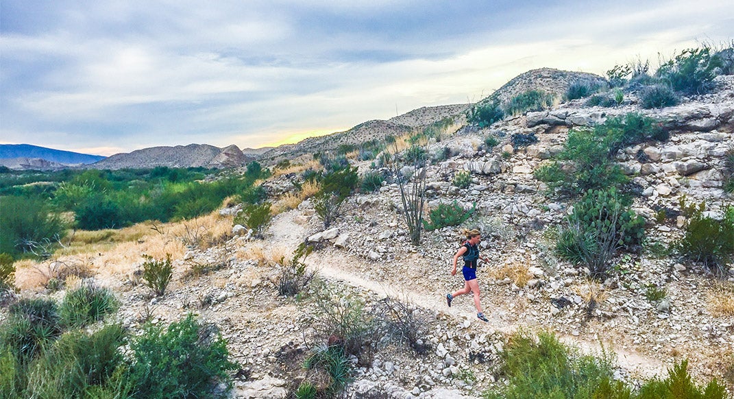
The Hot Springs Trail, found at the edge of Big Bend National Park, is six miles out-and-back (three miles each way), rugged in some areas but generally well marked. It takes runners along limestone cliffs above the Rio Grande, which marks the international border. You can start at either end of the trail but I always packed a towel and started running around sunset from the Hotsprings Trailhead. When I finished running I walked the half mile back to the free, 104-degree hot springs to watch the stars come out.
The Hot Springs Trail is just one of the great running options in Big Bend National Park. Another more ambitious run is the 12-mile Marufo Vega Loop Trail. This rolling trail takes you though harsh Chihuahuan Desert. Just when you think you’ve had enough, the trail drops 1,000-feet down the Rio Grande, and follows the river (and the border) for a few miles before climbing all the way back out.
Refuel: At this point you’re probably wondering about the tacos, right? Both of these Big Bend trails are close to Boquillas Crossing, where, if you bring your passport, you can grab a boat ride across the river for five bucks to buy a taco lunch with U.S. dollars, hassle free, in a Mexican village. You can go on a donkey ride too, if that’s you’re thing.
More information: https://www.nps.gov/bibe/planyourvisit/day_hikes.htm
ADVERTISEMENT
New Mexico
If you find yourself driving north out of El Paso, you’ll be heading into New Mexico and might as well stop at the Mount Cristo Rey Trail for a 4.5-mile run up to a 30-foot limestone statue of Christ with 360-degree views of El Paso and Juarez. The trail is wide and runnable, but gains almost 1,000 feet of elevation.
Refuel: If you’re getting tired of tacos, Ardovino’s Desert Crossing is a fancy Italian spot very close to the trailhead that works pretty well for those who like to carbo-load with class. Learn from my mistake: this is not the kind of restaurant to visit in your running clothes.
More information: https://www.hikingproject.com/trail/7012792/mount-cristo-rey
ADVERTISEMENT
Arizona
If you’re hitting the border in Arizona, then try out the little known Coronado National Memorial. This national park unit is tiny but full of run-worthy trails. Yaqui Ridge and Joe’s Canyon trails, can be combined in several ways to get runs from about three miles to nearly eight.
Park at the visitor center and run up the mountain for a long run, or park at the top and run the ridge for something shorter.
If you follow Yaqui Ridge it will drop off the southern end of the mountains and end right on the border with a nearly endless view into Mexico. (This is also where the Arizona Trail starts, opening up hundreds of miles of possibilities into Coronado National Forest). Busby, an abandoned mining town now taken over by hippies and Harleys, is an interesting tourist stop.
Just a few hours south of Tuscon in the Sonoran Desert, Organ Pipe Cactus National Monument is full of great trails. The Estes Canyon and Bull Pasture Trail loop takes you through the Ajo Mountains for about three miles. For something longer, follow the social trail that leads 2.5-miles up Ajo Peak from the end of the Bull Pasture Trail. This involves a little scree and scrambling (keeps out the riffraff) but the view is amazing.
Tip: In addition to trails, Organ Pipe is full cactuses trying to impale you. I love the feeling of trading shoes for sandals after a hard run, but given the abundance of Cholla cacti, I must strongly caution against this.
Refuel: Replenishing fuel and fluids (think tacos and margaritas) is difficult in Organ Pipe but if you brought your passport, then Sonoyta, Mexico, serves as a great oasis.
More information: https://www.nps.gov/orpi/planyourvisit/hiking.htm
ADVERTISEMENT
Mexico
To add another layer of adventure to this running enchilada, try dipping into Mexico to climb 11-miles round trip up Pinacate Peak Trail.
Cross into Mexico via the Lukeville Port of Entry just south of the Organ Pipe Visitor Center. Across from Lukeville, you’ll be in the Mexican border town of Sonoyta, where you can stock up on groceries and water before driving about one hour south on Highway 8 to the northern entrance of El Pinacate y Gran Desierto de Altar Biosphere Reserve. I found a scrappy tourist map that proved essential to navigate the area because, even though my phone worked in Mexico, the navigation apps were exactly incorrect in every single instance that I tried them.
After paying a few dollars per person to enter the reserve you can drive a rough dirt road to the Pinacate Peak Trailhead, and camp under towering Saguaro cacti. When you’re ready to run, just follow the wooden posts along an abandoned mine road that now serves as a pretty good trail. I started up the trail in early morning and watched the sun illuminate a dozen volcanic cones across the landscape. The final quarter mile turned straight up a scree slope, before topping out to stunning views across miles of sand dunes all the way to the Sea of Cortez.
ADVERTISEMENT
More information: https://www.nps.gov/orpi/planyourvisit/pinacate.htm
Other questions to ask before heading south:
Q: Does my health insurance cover me in Mexico?
A: Probably not.
Q: Where should I get Mexican car insurance?
A: Almost any town near the border has shops that sell it.
Q: Will my phone work in Mexico?
A: You’ll be lucky if it works in the remote border areas in the U.S.
Q: Do I remember anything from high-school Spanish?
A: Probably a little, but you can get by without knowing much if you have a good smile.
Q: How much is a Peso?
A: Who knows … most Mexican border towns will accept dollars.