Published April 26, 2017 10:34AM
Get Lost!
A wild trail run on the northern California coast
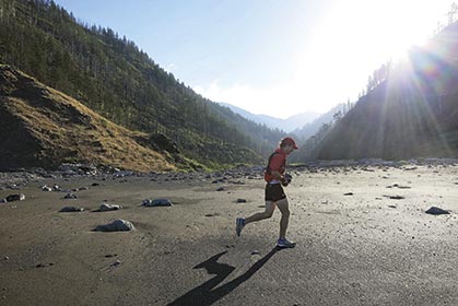
The author crossing Big Creek at the base of the Kings Range along the northern section of the Lost Coast Trail. Photo by Leor Pantilat.
In the gray, pre-dawn light I studied the outbound tide and the calm, lapping waves. “Never turn your back on the ocean,” I read on the trailhead sign before stepping on to the soft black-sand beach. I recalled a friend’s praise of the ocean as “immediate wilderness.”
Trailhead warnings are nothing new to us—lightning, bears, snakes, exposure, hydration—hazards always lurk beyond, putting the “wild” in wilderness, giving us a story to tell when we are safely back at the car admiring the patina of dirt and blood on our calves and ankles. A line where the sock starts and the fetid stench of 50-mile-feet continues below.
ADVERTISEMENT
An ocean, though, now gave me even more to fret about. I imagined a wave creature emerging from the sea, grabbing me by the shoulders and pulling me into the water without a peep.
“Well?” I said to Leor. “Shall we?”
We made our way to the water’s edge where the wet sand resisted our body weight some and bean-sized sand crabs leaped about at our feet.
With a northerly breeze at our backs we set off down the longest, uninterrupted coastline in the continental United States—the 56-mile-long Lost Coast of northern California.
My running partner for this adventure was Leor Pantilat—a man whose name was once ubiquitous across Bay Area ultra results and then gone completely. When I asked some fellow runners where he’d disappeared to, they suggested looking at his blog (pantilat.wordpress.com). There, I found that the energy once spent leading races had been reinvested into the research and execution of long, one-day running tours across California.
ADVERTISEMENT
Though our plans to tackle this run had been in the works and postponed for months due to conflicting schedules, unfavorable tides and occasional injury, the physical journey began only a day prior, as my girlfriend, Liz, had agreed to help with the unfortunate logistical need for a shuttle.
The four-hour drive north from San Francisco on U.S. Route 101 funnels down from five lanes with In-N-Out Burgers on either side of the highway, to the three lanes of wine country and finally to two. Pickup trucks replace the Prius and a counter-culture of hipnecks (redneck hippies) and marijuana ranges from subtle to conspicuous.
In the small Humboldt town of Garberville, we passed a store advertising marijuana-trimming supplies. “Your sticky fingers are welcome here!” said one sign. Pickup trucks cruised up and down the streets with bumper stickers reading “Another Logger Gone to Pot” and “Save Humboldt County, Keep Pot Illegal.”
We filled up on gas and began the slow, winding drive to the mouth of the Mattole River, where we would rest for the night before setting off in the morning.
ADVERTISEMENT
Though settlers, loggers and developers have been trying to tame the Lost Coast for over 150 years, what’s resulted has been little more than the running of fingers through the long, tangled hair of an unkempt land—a land with a propensity toward being untamed. With over 100 inches of rain per year, nature is quick to reclaim trails, roads and homesteads left untended. Redwoods grow hundreds of feet tall, mountain lions and bears roam freely, great white sharks patrol the coastline and every so often an unsuspecting person is swept off their feet and pulled into the cold deep blue.
Even Highway 1, stretching over 600 miles along the California coastline, known for its engineering feats of overcoming steep headlands, deep gulches and eroding cliffs, was finally directed 30 miles inland by the massive upheaval of headlands presented by the wilderness known as the Lost Coast.
Photo by Leor Pantilat.
Leor set the pace down the beach. Fair skin and hollowed facial features hint strongly of his not-so-distant Russian ancestry. By weekday he is a Silicon Valley lawyer, advising and assisting in companies buying companies.
“It’s not what people think,” he told me as we zigzagged about the beach in search of the firmest footing. “I don’t go to court. I don’t see a judge. I don’t wear a suit.”
I asked if he prefers the black briefcase or the more traditional accordion-style.
“No briefcase.”
ADVERTISEMENT
We were slowed to a crawl over an outcrop of rounded boulders covered in sea kelp.
This marked the third time that Leor has made the trip down the Lost Coast, and the first time that he had attempted to do it in a day. Throughout the course of our adventure, we would debate the merits of tackling the Lost Coast in a single day as opposed to two. But right then, we were simply enjoying the crescendo of light coming from beyond the King Range to the east.
Leor is encyclopedic with his knowledge of the -ologies of the area—ecology, biology, geology, meteorology. He explained the north-to-south wind patterns, the meeting of three fault lines—a geological intersection called the Mendocino Triple Junction—that created the massive uplift of land immediately next to the ocean. He told me that nowhere else in the continental United States does the land rise so abruptly from the ocean. I sensed that so much of the joy that Leor receives from a day of running comes simply from learning as much as he can about a place before he goes.
ADVERTISEMENT
Where the forces of nature meet: the high-water mark along a striated cliff band displays the importance of checking the tide chart before your departure. Photo by Leor Pantilat.
We paused at one of many places on the map that warned, “Impassable at high tide.” The coal-black, striated cliff, even at low tide, loomed menacingly close to the cold dark water. Leor pointed out the water line from the night before nearly two stories above us. In just a few hours the tide would return. The wave creature pulling me out to sea crept back to mind.
ADVERTISEMENT
Farther down the coast we hopped onto Big Flat, where a cruise-y, hardpack trail allowed for a brief reprise from the drudgery of beach running. Backpackers were camped out—some of them with surfboards hauled in from the next entrance, eight miles down the coast. Our fleet-footedness seemed to provoke a common level of disdain and contempt amongst the hikers.
Spanish Flat provides a rare bit of trail along the northern section of the Lost Coast Trail.
We continued down the beach and, 25 miles after leaving the Mattole River, arrived in the small resort town of Shelter Cove, where Liz was waiting for us with food, water and a smile.
The unincorporated town of Shelter Cove marks a halfway point along the Lost Coast. The narrow, windy road leading in from Garberville, 25 miles to the east, keeps the town quiet, if not a little claustrophobic. There is no Main Street and no town center. Heavy, iron gates block most driveways, secured with a chain and a padlock and what few residents we came across gaurded their smiles and hellos behind a thick wall of Jurassic foliage.
Whether as pot growers or retirees, one thing is certain in Shelter Cove—people like to be left alone.
ADVERTISEMENT
With the ocean briefly at our backs, we carried on 2,000 vertical feet up the road out of Shelter Cove to the next trailhead at Hidden Valley. From there the second half of the Lost Coast became as distinct as the first. From the 2,500-foot summit of Chemise Mountain, we descended slowly back down to the waterfront, passing through the polished-brown groves of madrone and for a brief moment, the accumulated miles allowed me to be running somewhere above the Mediterranean.
As much as the first half of the Lost Coast trail is defined by its relationship to the ocean, the second half is defined by its relationship to the coastal mountains. The steep valleys and abrupt features that prohibit beach travel provide real estate for a half-dozen microclimates and eco-zones. Bold groves of redwoods, fir and alder stand segregated from each other. A thick undergrowth clogs every drainage. The trail thins, and the many backpackers we saw in the first half declined to but a tough few.
We had covered 40 miles by midafternoon as we arrived at what remained of a 1920s dairy operation—an old barn and the Stewart family house overlooking abandoned pastures and expansive ocean. Adopted by the State Park, the building is now known as the Needle Rock Visitor Center, where a live-in docent greeted us with water and nuts and an update on the wildlife he’d seen in the past month. As we headed out down the trail, he casually warned us of bears and mountain lions.
ADVERTISEMENT
We zigzagged up another thousand feet and zigzagged back down. A crumbling concrete pad was all that remained of another homestead that had been gobbled up by this wild land. The elevation profile, I realized, started to closely resemble a healthy heartbeat line. Up another thousand feet, down another thousand feet—from Bear Harbor up to Jackson Peak, down to Jackass Creek up to a nameless ridge and down through a redwood grove into aptly named Dark Gulch.
We made our way up the final climb, as the sun approached the horizon and our 50-mile-legs took on a drunken clumsiness. The orange-red sun ignited the air around us. Insistent on seeing out every last viewpoint, Leor dutifully snapped a picture to add to his blog—this one to show Usal Beach not far away, and the paved ribbon of Highway 1 just beyond.
We cruised down the last of the trail—a soft bed of redwood needles providing much appreciated cushioning. Nearly 14 hours had passed as we arrived at the southern terminus of the Lost Coast Trail, where some local teenagers stood around a pickup polishing off the last of a suitcase of beer and not far away Liz sat in her car listening to NPR.
ADVERTISEMENT
Whether as a few-days getaway or as a last, lawless frontier to live out your harbored dreams of homesteading, the Lost Coast of northern California is the untamed playground that has earned its name with the unforgiving hand of entropy.
Trailhead: Lost Coast Trail, California
>When to go: Though the Lost Coast can be undertaken year-round, running from May to September will increase your chances of good weather and longer days.
>Getting there: You can run the Lost Coast in either direction, however, a north-to-south direction will likely put the prevailing wind at your back and allow for easier planning with the tides.
The trailhead at the northern end of the Lost Coast is found at the mouth of the Mattole River, one hour west of Garberville and another four hours north of San Francisco on Highway 101.
The Lost Coast finishes at Usal Beach—accessed by a six-mile drive on a winding, dirt road from Highway 1 (low-clearance vehicles OK). The turnoff is oftentimes unmarked, so it’s best to measure the 15 miles along Highway 1 west from the small town of Legget on Highway 101.
ADVERTISEMENT
>One day or two? (Or … Do as I say and not as I do.) The Lost Coast stretches along two counties and is divided into two different government land protections: King Range National Conservation Area and Sinkyone Wilderness State Park. Appropriately, the Lost Coast Trail is best undertaken as two parts—the northern beach section and the southern headlands section.
>Maps: The Lost Coast is fairly easy to navigate; however, poring over Wilderness Press’ California’s Lost Coast will give names to creeks, cliffs, bluffs and many other trail features.
>Camping/Lodging: If you’ve made it as far as the Lost Coast, you might as well stay a few days. Camping is available at both trailheads (Mattole Beach and Usal Beach) and at the halfway point of Shelter Cove (although there is in-town camping, Tolkan, Nadelos and Wailaki campgrounds outside of town are cheaper, quieter and friendlier). For those who prefer a hot shower and comfy bed between runs, Shelter Cove offers several ocean-front inns ($150-$300/night).
>Shuttle: A shuttle can be avoided if you are willing to bike the 100 miles from trailhead to trailhead around the Lost Coast. If that’s not in the cards, you’ll need to bribe a driver with food, wine and beautiful beachfront car camping.
>Tides: Ocean tides and currents are a real threat along the northern section of the Lost Coast. Go to www.tidesandcurrents.noaa.gov for tide predictions. And remember: “Never turn your back on
the ocean!”
This article originally appeared in our October 2014 issue.