Published April 26, 2017 10:36AM
From Sea to Summit
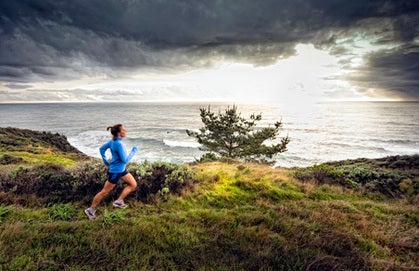
Running wild in Big Sur, California
Curving south out of Carmel, California, on Highway One, I put the pedal to the metal on my car loaded with two trail runners, a dog …
Photos by Kevin Steele
Curving south out of Carmel, California, on Highway One, I put the pedal to the metal on my car loaded with two trail runners, a dog and a passel of camping gear. We are headed to Big Sur, where North America takes a topographic tumble into the Pacific Ocean. My foot is leaded by dreams of the trail-running vacation beginning now.
ADVERTISEMENT
The road soon narrows and abandons most traces of civilization. Our route wobbles left, then wends right before opening to The Big View. A friend told me to grip the steering wheel tight on this highway because Big Sur would blow my mind, and she was right. To our left, orange peaks rake a ragged line across a cloudless sky. On the right, steely ocean waves crinkle toward shore in white-capped creases.
With these views, I want to pull the car over, jump out and run wild. Just four hours ago, I surprised my traveling companion and boyfriend, Bryon Powell, with this trip, giving him just enough time to pack a bag before hitting the road from our home in California’s Sierra Nevada foothills. When I tell him I can’t wait much longer to run, his response is all I need to hear: “Where do we start?”
Big Sur Basics
Big Sur encompasses over 90 miles of California coastline between Carmel and San Simeon. Reaching inland from the ocean for about 20 miles, it also includes the Santa Lucia Mountains, which rise over a vertical mile from the sea and contain hundreds of singletrack miles. “In Big Sur, rugged terrain and a feeling of isolation dominate,” says Brian Rowlett, an adventure runner and a resident of Carmel Valley, which lies east of Carmel. “On a long run, you kind of disappear. You may know exactly where you are, but as far as the rest of the world is concerned, you’re gone. If you don’t come back, no one will stumble upon you. Not soon, anyway.”
ADVERTISEMENT
Highway One runs the north-to-south distance of Big Sur (and beyond) and serves as the region’s singular access point, adding to the sensation of seclusion. The road itself is an engineer’s miracle, roller coastering over ocean bluffs, meandering around yellow sand beaches and clinging precariously to sea cliffs.
Here and there are smatterings of private land containing eating establishments, inns and campgrounds serving Big Sur’s tourists. Most of the real estate, though, is entrusted to either the California Department of Parks and Recreation or U.S. Forest Service. So extensive and remote is Big Sur that it also enshrines two wilderness areas.
Called by the Wild
Over and over, I skid into the gravel of the road’s scenic pullouts. We stare without words into a cyan ocean. We gawk at the historic Bixby Bridge, a Depression-era public works project that provides automobile access to Big Sur, and the technicolor canyon it still spans. We sit on a bluff and watch sea otters twirl and toss kelp like children swinging Wii remotes. We peer over a cliff just in time to see a swell pummel it in a spin cycle of whitewater.
ADVERTISEMENT
When we can’t stand it anymore, we peel off our traveling clothes, lace up our running shoes and turn our toes up the Vicente Flat Trail. It climbs hard and fast at a barely runnable grade, and I am working to keep up with Bryon. He’s a two-time, top-10 Leadville 100 finisher with powerful thighs the size of railroad ties, but he is using them to put only a moderate hurt on me today.
Following the trail’s sea-view switchbacks, we run through waist high grasses and the orange glow of afternoon sun refracts through salty air. The guidebook warned us of rampant poison oak on Big Sur’s trails and immediately we recognize its three-leaf warning. We prance around the poisonous plants while watching pelicans circle the ocean. A thousand feet up, Bryon says, “Can’t hear the crashing waves up here,” just as a group of gulls makes squawking swoops in the wind.
After perhaps four miles, the grass gives way to a fern-floored forest of redwood trees. Impossibly tall and close growing, they create complete shade and natural air conditioning on this warm, humid day. Though the thick canopy makes it difficult to discern, I am certain that the trail has changed its orientation, turning away from the ocean and into a canyon.
ADVERTISEMENT
We are breathing heavily with the climbing and thick air, so we stop for a moment of standstill quiet. Silence reigns, save for a trickle of water from something, somewhere. We both break into smiles over discovering this wild place just an hour up the trail.
Where the Wild Stuff Is
Ultrarunner Whit Rambach, 44, of Carmel, grew up exploring the Big Sur backcountry and still enjoys long runs there. “It has awe-inspiring views, fresh coastal air, an incredible variety of flora and fauna, few humans and unforgiving terrain,” he says. “It is true wilderness.”
Perhaps the icing on Big Sur’s cake, though, is its biodiversity. Land-lubbing trail runners fast recognize terra firma as a place where the wild stuff is. That Big Sur hosts an annual monarch butterfly migration, possesses resplendent hillsides of spring wildflowers, provides one of the California condor’s few homes and sports a dense mountain-lion population are just a few examples of the region’s land-based biotic abundance.
ADVERTISEMENT
The Pacific Ocean is as much a wilderness as Big Sur’s mountains and canyons. Blubbery elephant seals lounge awkwardly on rocky points. Three whale species either migrate through or call the waters of Big Sur their home. Tidal pools reveal smaller sea creatures, including spindly sea urchins and snappy clams.
Fold this land and ocean-based biodiversity together with Big Sur’s rugged landscape and robust trail system and it becomes clear that this is also a place where trail runners should be. “Running in Big Sur is absolutely wild. Even experienced trail runners can sometimes feel overmatched,” says Donald Buraglio, a long-time Carmel-area resident, ultrarunner and blogger. “I always have a heightened sense of awareness out there, which makes the trail-running experience more profound.”
A Wild Descent
We check our watches, do some fast math and realize that this will be today’s turnaround point if we want to beat darkness to our campsite. On the climb, I enjoyed the long views of the Santa Lucia Mountains’ 5000-foot peaks and the wild blue ocean expanse. On the descent, I appreciate the trail’s buffed-out surface. We float down the mountain, legs moving fast with each footfall into the fine-grained, grippy dirt. Where the trail curls upon itself, we flail and flap our arms to guide our turns.
ADVERTISEMENT
We soon return to the tall grass and I hear the ocean’s roar. I catch glimpses of Highway One snaking along the land’s contours, the first sign of humanity in hours. When we arrive back at the trailhead, we are covered in a sticky mix of perspiration, ocean salt and poison oak’s toxic urushiol. Bryon grins and says, about both this trip and the trail, I suspect, “That was a nice surprise.” We remove the irritant with a Technu wipe-down, take a few pulls on a bottle of cold water, gobble up some juicy watermelon and settle into the Kirk Creek Campground for the night.
Throwing together dinner over a camp stove, we stretch our legs between stirs of the pot and turn west to watch a fireball sun drop below the sea’s horizon. The Kirk Creek Campground, a small Forest Service campground perched 100 feet above the ocean on a grassy bluff, provides us with a wide-open westward view. Without meaning to, I find myself fist pumping the sunset, the first day of our Big Sur vacation and being smack in the middle of where the wild things are.
BIG SUR’S WILD TRAILS
Ridge, Panorama and Bluff Trailsloop at Andrew Molera State Park (A nine-mile loop, 23 miles south of Carmel).
From the trailhead, head south and use the footbridge to cross the Big Sur River. Run for less than a mile on the Creamery Meadow Trail before turning left on the Ridge Trail. Meander uphill through trees and open meadows yielding inland views. The trail turns first into the Panorama Trail and second into the Bluff Trail. Both possess prized ocean vistas. Run all the way to the beach and turn right on the Beach Trail to return one mile to the trailhead.
ADVERTISEMENT
Pine Ridge Trail to Sykes Hot Springs and return in PfeifferBig Sur State Park and the Los Padres National Forest (20 miles round trip, 28 miles south of Carmel).
Park at Big Sur Station and head out on the Pine Ridge Trail. Find moderate to steep climbs in the first few miles, then contouring singletrack through forest above the Big Sur River. Wade the river for the last mile to Sykes Hot Springs, a series of small, stone-lined, clothing-optional pools.
Limekiln State Park Trails (About three miles of trails, 53 miles south of Carmel).
Three out-and-back trails travel along gentle singletrack, through redwood stands and to waterfalls. Visitor services in Limekiln State Park may close in the fall of 2011 due to state-park budget cuts, but trails are likely to remain accessible. Call the park at 831-667-2403 for up-to-date information.
Cone Peak via the Vicente Flat Trail out-and-back in the Los Padres National Forest (23 miles round trip, 55 miles south of Carmel).
Park across the highway from the Kirk Creek Campground and head up the Vicente Flat Trail, which climbs steadily for about eight miles to the Cone Peak Road. Turn left and run this fire road for about 1.5 miles, then turn left again onto the Cone Peak Trail. It is two more steep miles to Cone Peak’s summit. “This run has it all. Elevation change? Sea level to 5150 feet and back,” says Flyin’ Brian Robinson, the course-record holder for North Carolina’s crazy Barkley Marathons who lives north of Carmel in Monterey. “Variety? Start on the beach, cruise up one of Big Sur’s signature ridges emerging from the sea. Follow a pristine creek in a redwood canyon. Climb the canyon headwall. Follow a ridge to the granite summit that feels like it could be in the Sierra Nevada.”
ADVERTISEMENT
Trailhead :: Big Sur, California
Getting There. Big Sur’s north end begins in Carmel, a 75-mile drive south from San Jose, California. Access almost all of Big Sur’s trails via California’s Highway One between the towns of Carmel and San Simeon.
Accommodations and Camping. Though the coastline is dotted with campgrounds and lodging facilities, regional standouts include the exclusive Post Ranch Inn (24 miles south of Carmel), the bluff-top tent sites of Kirk Creek Campground (55 miles south of Carmel) and Plaskett Creek Campground (60 miles south of Carmel), Treebones Resort’s quirky yurts (63 miles south of Carmel) and the romantic Ragged Point Inn (77 miles south of Carmel).
Weather. A mild, marine climate dominates the Big Sur coastline, with 50 plus inches of rain falling mostly between November and April. The Santa Lucia Mountains create a rain shadow for the region’s eastern wilds that results in hot, dry summers. Trail run year round here, but beware of frequent downed trees and high-water crossings during the rainy season.
Races. The Big Sur Trail Marathon, Half Marathon and 5-Mile Races are held in September each year at Andrew Molera State Park (23 miles south of Carmel) (www.envirosports.com).
Maps and Resources. All of the region’s trails are digitized in National Geographic’s Weekend Explorer 3D—San Francisco Bay Area and Big Sur, Napa Valley CD ROM. Analise Elliot’s Hiking and Backpacking Big Sur: A Complete Guide to the Trails of Big Sur, Ventana Wilderness, and Silver Peak Wilderness provides precise route descriptions. The Ventana Wilderness Alliance maintains a trail-conditions website forum where area officials and trail users leave up-to-the-moment reports (www.ventanawild.org).
Environmental Considerations. Kim Neill, a Carmel native and ultrarunner now based in Boise, Idaho, says, “Poison oak is prolific in Big Sur. Exposure to it is inevitable, as branches hang over narrow trails and bare branches blend in with other vegetation. After a run, wipe down exposed skin with alcohol or Technu and wash your clothing and shoes.” Ticks can also be a nuisance, particularly in spring and early summer; cover bare skin and do a thorough tick check after a run.