Published October 11, 2016 09:48PM
New App Aims to Be "Definitive" Source for Local Trails
You want to get in a run while you’re in a new place, and make sure you hit the best local spots. Enter the new app Trail Run Project.
Any trail runner who has traveled knows the feeling: You want to get in a run while you’re in a new place, and make sure you hit the best local spots. You consult whatever you can find online, or maybe a local running shop, but there is no consistent place where you can compare different trails consistently, let alone get a readout on current conditions.
Enter the website and mobile app Trail Run Project.
Founded in 2015 by Nick Wilder and Mike Ahnemann, who had created similar projects for climbers and mountain bikers, Trail Run Project (TRP) compiles local trails as submitted by the people who have run them. Users can search any geographic area in the world, whether they are visiting a new town or are brand new to trail running and looking for the best spots in their backyard.
“We initially created these sites for ourselves,” says Ahnemann, referring to Mountain Project, which Wilder founded in 2005 for climbing routes, and which later grew to include TRP. “We were frustrated when we’d travel to a new place because it was always impossible to figure out where to get out on the trails. So it’s a go-to resource for runners traveling to a new area, new in town, or new to the sport.”
ADVERTISEMENT
Local Knowledge with Guidebook Quality
Trail Run Project is not the first place to “crowd-source” (or “expert-source”) local trails. For example Roots Rated offers in-depth profiles of local trails (and other recreation spots) written and submitted by knowledgeable locals; users can search out places to go based on their location and the activity they want to do (RR lists everything from hiking to whitewater rafting and disc golf). Like TRP, they list some details like distance and seasonability.
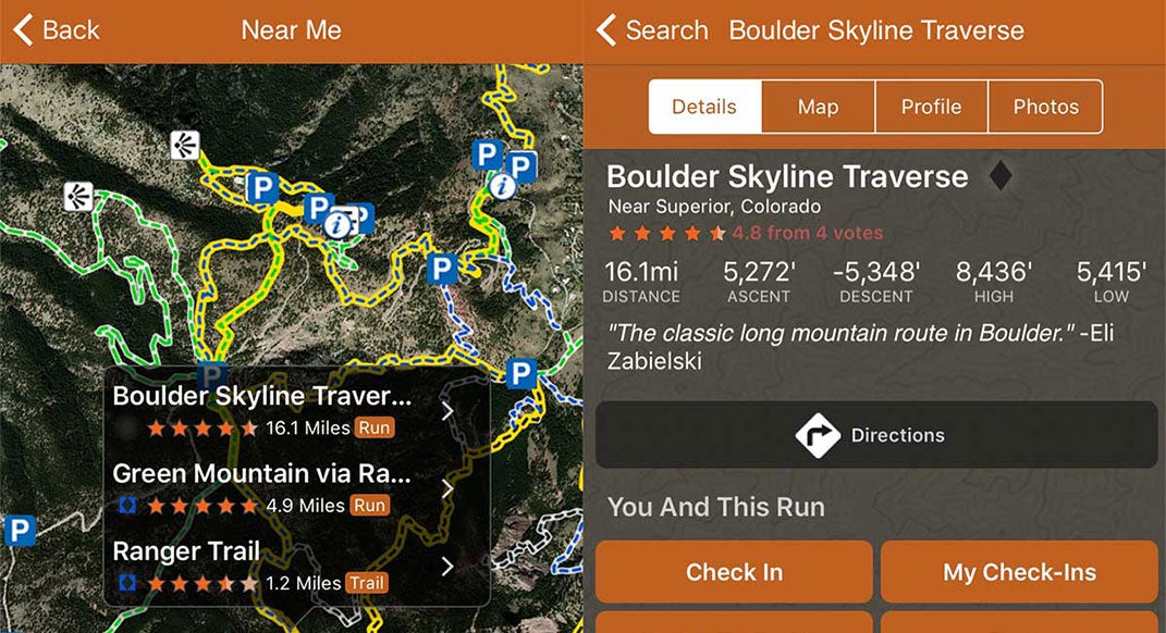
Aside from being 100-percent focused on trail running, the key difference is that TRP’s team, according to Ahnemann, is more thorough in its analysis of each trail in order to ensure that all trails can be compared by the same standards. In addition to word-of-mouth reports from local experts, TRP gives each trail a consistent statistical rundown, so users can compare trails in different states and counties, apples-to-apples. Plus, TRP includes an elevation profile, key for trail runners who want a more challenging route than dirt loops around a lake.
ADVERTISEMENT
“We have guidebook-quality trail descriptions and photos. Every single mile of trail and every photo is reviewed by our content team for trail legality, mapping accuracy and complete descriptions,” Ahnemann says. “You can preview a trail on a ‘virtual run'”—a flyover of a 3D simulation of the terrain, following a runner icon along the route. “We have an elevation profile with grade for every inch of trail, plus a spot forecast for trail conditions.”
TRP’s mobile app also shows a user’s current location on a map, mid-run, to prevent runners from getting lost on a new trail.
“The app will be the most complete guide to trails that exists for runners,” Ahnemann adds. “[It] will become the definitive source of information on where to run.”
Incomplete but Growing
To test the Trail Run Project site and app against my own knowledge of local trails (which has, in turn, been handed down to me by other, more experienced trail runners), I scanned its listings for two Minnesota trail hubs, the Twin Cities and Duluth.
ADVERTISEMENT
What I found were very thorough listings for Lebanon Hills Regional Park and Afton State Park, two go-to trail runs near St. Paul, with accurate descriptions of difficulty and the makeup (singletrack, doubletrack, etc.) of different sections. There were similar profiles of Lake Elmo Park Reserve in the east metro and William O’Brien State Park to the northeast, though I am not personally familiar with either.
The trails were easy to find, both by using the search feature and by scanning the map, though it was difficult to click on a listing; hovering over each blue-highlighted spot offered a link to the trail’s information page, which disappeared before I could click on it, unless I first clicked on the blue spot.
There is also the issue of completeness. The site highlights the Superior Hiking Trail (SHT), which, with around 300 miles along the rugged coastline of Lake Superior, is undoubtedly Minnesota’s crown jewel. While the information in the entry was complete (299.7 miles, 33,948 feet of ascent), the trail was only highlighted south of Duluth, at the trail’s southern terminus, and not at other spots farther north, where the SHT has trailheads every few miles. Each of those unique sections merits a rundown as thorough as those for each section of Afton. For now, visitors north of Duluth might be left thinking there are no good options from the SHT’s placement on TRP’s map.
ADVERTISEMENT
Additionally, several go-to spots in the Twin Cities were absent. For all the thoroughness of the Afton and Lebanon listings, glaring absences included Hyland Park Reserve in Bloomington, French Regional Park in Plymouth, Elm Creek in Maple Grove, Battle Creek in St. Paul and Theodore Wirth Park, our ultimate urban hidden gem nearly adjacent to downtown Minneapolis.
Of course, the site is new and growing, and the whole point is for users like me to go in and add those listings. Over time, the gaps should be fewer and fewer. (And really, I can’t grumble about the site’s listings if I don’t take time to add them myself.)
Ahnemann says the site recently passed the 10,000-trails mark and has an average of 30 new listings uploaded each day. TRP might not yet be the “definitive” source for local trails, but if users keep up this pace, the app certainly could be sometime soon.
Engaging Runners
Thanks to backing from REI, which bought TRP’s parent company Adventure Projects (which also includes Mountain Project, MTB Project, Hiking Project and Powder Project) in June, the app will be free to use.
ADVERTISEMENT
“In return, the community supports the sites by providing trail descriptions and photos of their favorite local trails and information to fellow members,” Ahnemann says. “With this app, everyone can hit the trails with the inside knowledge of a local.”
He says the site also recently formed an editorial team to create content useful to runners and other users.
“Trail Run Project will also become a source of inspiration and connection to the broader community as the site grows,” Ahnemann says. “We want all runners to get involved … to discover new trails, and share their favorites.”