Published April 26, 2017 10:34AM
Wild Backyards
7 top trail towns with true wilderness out the door
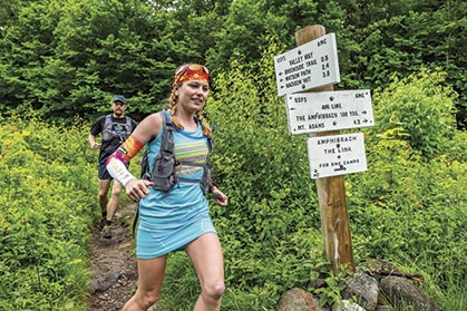
Kristina Folcik-Welts, female FKT-holder for the Presidential Traverse, and her husband, Ryan Welts, take on the White Mountains. Photo by Joe Viger
Each year, we go hunting for towns around the country that make solid trail-running vacation destinations, both for their metropolitan offerings and their access to singletrack. This year, we’ve chosen seven towns—from the massive megopolis of Los Angeles, California, to the mountain village of Ouray, Colorado—that are gateways to serious wildlands.
We’re not talking about quaint urban retreats or little trail networks. We’re talking granddaddy landscapes, thousands of acres of preserved lands and hundreds of miles of trails, the biggest playgrounds our country has to offer.
Sage Canaday in the famous, grueling Mount Washington Road Race. Photo by Joe Viger
Conway, New Hampshire: White Mountain High
Located in east-central New Hampshire, Conway is best described as a year-round adventure destination. At about 10,000 folks including the resort village of North Conway, the town is located in the flat Mount Washington Valley with the White Mountains rising not so subtly around it. Kristina Folcik-Welts, a 36-year-old ultrarunner and dental hygienist from Northwood, New Hampshire, who spends time each year running in the White Mountains, describes the town’s feel: “Conway feels touristy, but it’s a great respite from the daily grind and a place to find peace in the mountains.”
ADVERTISEMENT
Conway sits on the eastern margin of the White Mountain National Forest, which encompasses the White Mountains and is one of New England’s most remote and wild areas. The Whites have been a tourist destination from the mid-1800s, so outdoor-recreation infrastructure is well developed. There’s everything from hiker shuttles to mountain huts, and the trails themselves seem old in places, widened and rutted by long use.
If you do only one thing on your visit to Conway and the White Mountains (as long as it’s summer and the weather is good), it’s to get yourself atop Mount Washington, the range’s 6,288-foot high point. You can go by foot, private car, tour van or cog railway. Up there, you’re sure to find yourself a White Mountain high!
Photo by Joe Viger
Top Trails
> Mount Osceola and East Osceola Mountain out-and-back in White Mountain National Forest. At 7.6 miles roundtrip, you visit the lesser-used Sandwich Range, a sub-range within the White Mountains. From the top of treeless, flat and rocky Mount Osceola (4,315 feet), clear weather yields a view of the Whites, whose thickly forested bases yield to gnarly granite tops. The last mile is exposed and rocky, a fun beginner scramble.
> Little Haystack Mountain, Mount Lincoln and Mount Lafayette Mountains loop in White Mountain National Forest. “Lots of ridge running in a short distance” is how Folcik-Welts describes this nine-mile loop featuring 3,800 feet of climb. On the Falling Waters Trail en route to Little Haystack Mountain, you’ll run past mossy cascades and small waterfalls over smooth, slippery rocks. Running to Mount Lincoln and Mount Lafayette, you’re above treeline and views of the Whites extend every which way.
> Presidential Traverse point-to-point in White Mountain National Forest. At a minimum of 18.5 miles, 8,500 feet of climb and passage over eight summits named for U.S. Presidents (including the most famous of those peaks, Mount Washington), this route is one of the crown jewels of foot travel in North America. Most people go north to south. Says Folcik-Welts, “Don’t expect the miles to just tick by.” She says it’s severely rocky and, at places, just a cairned route through boulder fields. Expect to be out all day. (See “Fast Times and Aesthetic Lines,” March 2014, Issue 94.)
Photo by Joe Viger
Icon Races
> Cranmore Hill Climb. Held at Cranmore Mountain Resort in North Conway, the Cranmore Hill Climb takes place each July and is an anchor in the regional running community. It also now serves as the U.S. Mountain Running Championships, where the U.S. Mountain Running Team is chosen for participation in the World Mountain Running Championships every other year. Making two laps to the top of the ski resort on grassy and rocky ski runs, you’ll grab 2,400 feet of vert in about 13 miles at this race.
Get There
The Portland International Jetport is the closest airport, in Portland, Maine, 56 miles southeast. Your own vehicle is key to experiencing the White Mountains.
ADVERTISEMENT
Play Tourist
The Conway Scenic Railroad uses vintage railroad cars for scenic tours. From mid-September to mid-October, whole mountainsides rip roar in red, orange and yellow as the leaves change color. Nearby Echo Lake State Park is known for its beach going at the lake and rock climbing at Cathedral Ledge.
Take Note
The Appalachian Mountain Club offers a shuttle service among a number of stops through the White Mountains during hiking/running season that allows point-to-point travel in many places. Folcik-Welts says weather in the Whites is notorious for its fast changes, especially in the highest part of the mountains, the Presidential Range. Be prepared for high winds and fast-incoming storms.
A LOViT 100K runner under a Ouachita woodlands canopy. Photo by Arkansasoutside.com.
Hot Springs, Arkansas: In Hot Water
It’s the hot water that has always drawn people to what’s now Hot Springs in west-central Arkansas. First, multiple tribes of Native Americans soaked in the natural hot-springs water, which is believed to have originally emerged from several-dozen springs on the side of Hot Springs Mountain, on which the town of Hot Springs now sits. Later, Europeans came exploring, following stories of the water’s healing properties.
ADVERTISEMENT
By 1832, Hot Springs was set aside as a federal reserve, a precursor to a national park back before the U.S. government had invented such a thing. In 1921, the reserve became Hot Springs National Park. The city of Hot Springs today encompasses the national park, and its economy is largely tourism- and service-based.
Hot Springs also sits near the eastern edge of the Ouachita Mountains, an east-west trending mountain range with a 2,753-foot high point and contained within the Ouachita National Forest. While calling the range true “mountains” might be a stretch, you’ll still get short, steep pitches up and over long ridgelines. The national forest contains a lifetime worth of singletrack, and it’s wild out there! Even black bears range in the Ouachitas.
Photo by Justin Meissen/Creative Commons.
Top Trails
> Ouachita National Recreation Trail (ONRT) out-and-back from Highway 27 (five miles north of the village of Story, an hour from Hot Springs). The ONRT is a 223-mile trail extending the east-west width of the Ouachitas. Terrain to the east of Highway 27 is more gentle while terrain to the west is littered with hills. Whichever direction you travel, you’ll be under a nicely shaded, hardwood-forest canopy. The singletrack is almost entirely runnable.
> Lake Ouachita Vista Trail out-and-back from Brady Mountain Road in the Ouachita National Forest. Called LOViT by the volunteers who have lovingly built this trail, it traces the southern shore of Lake Ouachita, northwest of Hot Springs. Your objective is the top of Bear Mountain, a ridge running along the south side of the lake. It’s a grunt up Bear Mountain, but it’s all runnable and less than two miles to where things level off. On top, view the lake’s midnight-blue waters and the forested Ouachitas. From there, the trail remains rocky, with brief steep pitches. It’s 10 miles from the Brady Mountain Road Trailhead to the next road to the west, allowing for lots of room to roam.
> Eagle Rock Loop from the East Trailhead on Forest Service Road 106 in Ouachita National Forest. This loop is a Ouachita Mountains marathon, ringing in at 26.8 miles. Travel counterclockwise first on the Little Missouri River Trail, then the Athens-Big Fork Trail, the Viles Branch Trail and the Little Missouri River Trail again. The Athens-Big Fork Trail is the most exciting as you ascend and descend six ridgelines with valleys and creeks in between. On the ridgelines the Ouachitas’ thick forests break for long views to valleys and ridges beyond. This route requires fording the Little Missouri River many times, refreshing when it’s hot and not recommended at high water.
Icon Races
> Arkansas Traveller 100 Mile. This fall will host the race’s 24th running, which takes place all in Ouachita National Forest. The race begins with a figure-eight loop that includes eight miles of singletrack on the ONRT. The balance of the race is 83 miles out-and-back on forest-service dirt roads. Southern hospitality is at its finest here, as the race feels like a family that welcomes returnees and strangers alike.
Get There
The closest commercial airport is the Bill and Hillary Clinton National Airport in Little Rock, 56 miles northeast. Hot Springs has public transport, called Intracity Transit, making travel around town a cinch, but you do need a vehicle to access trailheads.
ADVERTISEMENT
Play Tourist
Begin at the Hot Springs National Park Visitor Center in the historic Fordyce Bathhouse to learn about the region’s thermal and bath history. Next do a short run or hike on the national park’s trails, until you find a scenic viewpoint looking down into the historic part of town. It’s really about the baths here in Hot Springs, which make excellent means of recovery from trail running.
The historic Buckstaff Bath House, located on Bathhouse Row, operates a lot like it would have in the 19th century. You can also rent a canoe or kayak to take out on one of the nearby lakes. More recently, Hot Springs has become a fine-art hub, so you’ll find ample galleries.
Take Note
The combined heat and humidity of summer is a beast. Expect highs in June, July and August in the 90s and equally high percentages of relative humidity. Poison ivy is widespread; give yourself a Technu washdown after your runs. Copperheads and a couple of rattlesnake species call the Ouachita Mountains home, as do ticks.
ADVERTISEMENT
Sandy singletrack on the Pacific Crest Trail, northeast of Los Angeles. Photo by Larry Gassan.
Los Angeles, California: Take Flight
You might be surprised to find the United State’s second-most-populous city on our list of places serving as portals to real wildlands, but you will find no better example of an enormo-city with just-as-big empty spaces so close.
Of course, Los Angeles has everything you need to get your city fix. There’s the glitz of Beverly Hills and Hollywood, the muscles of Venice Beach, the laid-back hipster feel of Santa Monica and the white-collar hustle of downtown. But when you’re ready to take flight, the trails outside of the city await!
ADVERTISEMENT
The singletrack-rich Angeles National Forest is located immediately to L.A.’s north and northeast. Let’s put it this way: the mountains there climb up to 10,000 feet above sea level, which is, uh, just about 10,000 feet above Los Angeles. Serious vertical. To L.A.’s west is the Santa Monica Mountains National Recreation Area (SMMNRA), protecting the landscape immediately inland from the Pacific Ocean and offering singletrack, stiff sea-cliff climbs and stiffer sea breezes. And beyond these immediate protected areas are even more, like the San Bernardino and Los Padres national forests.
Says Keira Henninger, a 37-year-old race director for L.A. area trail races such as the Sean O’Brien 50-Mile, 50K and 26-Mile, which take place in the SMMNRA, “From the city where there’s something to do day and night to the trails where the scenery varies from high, rocky mountains to ocean views, L.A. is best described as ‘diverse.’”
Gateway to wilderness. Photo by Bigstock Photos.
Top Trails
> Backbone Trail in Santa Monica Mountains National Recreation Area. Traversing the length of the SMMNRA, the trail runs ridgelines a couple thousand feet above the water. The closest trailhead to L.A. is at the trail’s eastern terminus in Will Rogers State Historic Park. “This is the home of the SoCal Coyotes, and they are rambunctious and friendly,” explains Henninger about the L.A.-based trail running group. “Almost anytime you run the Backbone Trail, you’ll run into a Coyote training. Also, join one of their group runs.”
> Mount Baldy loop in the Angeles National Forest. This 10.8-mile loop is accessed at the Manker Flats Campground, located at about 6,000 feet altitude on the south side of the mountain, more formally called Mount San Antonio. It’s the highest point in this mountain range, at 10,064 feet.
> Pacific Crest Trail point-to-point from Wrightwood to Islip Saddle in the Angeles National Forest. Some 176 miles of the 2,650-mile Pacific Crest Trail (PCT) wander through the Angeles National Forest northeast of downtown L.A. “You’ll see civilization down below, but you’re on your own up there,” says Henninger. Use a car shuttle to run the first 26 miles of the Angeles Crest 100 Mile course, from the Acorn Trailhead in Wrightwood, up to the PCT and along it to the Islip Saddle Trailhead on the Angeles Crest Highway. You’ll go up and over 9,399-foot Mount Baden-Powell and be ridgeline running or traversing almost the whole way.
Icon Races
> Angeles Crest 100-Mile Endurance Run. Held for the 27th time on August 2, this is an iconic race because many of the top 100-mile runners in the U.S. have tackled it at some point and because it runs point-to-point—uncommon for 100s in this era—over a bold backcountry course.
Get There
Los Angeles International Airport, baby. Rent a car and get the heck away from the airport as soon as you can.
ADVERTISEMENT
Be a Tourist
So much to do, so little time! The La Brea Tar Pits are fascinating, an Ice Age history haven amidst L.A.’s chaos. The Santa Monica Pier is a worthy tourist trap, as is Muscle Beach Venice (bring your workout clothes for some cross training). The Getty Center is an architectural marvel on a ridgetop offering a wide-open ocean view outside and priceless works of art inside. Sunset during a drive on the Pacific Coast Highway is quintessential L.A.
Take Note
L.A.’s traffic is perhaps the worst in the country. Do your driving on off hours or base yourself near where you want to play. Rattlesnakes and mountain lions range in the wildlands around Los Angeles; stay vigilant. Some trails, like the Mount Baldy trail system, can be very busy, so use proper trail etiquette.
A Hardrock Hundred runner follows in the footsteps of the original Hardrockers. Photo by Matt Trappe.
Ouray, Colorado: Hard Rockin’
Drive into Ouray, park your car and stand on Main Street. It won’t take but a moment to get past the modern visuals of dirtbag Subarus and jacked-up jeeps headed for the hills to arrive at the sensation that you’ve stepped back in time.
ADVERTISEMENT
It was 1875 when prospectors made their way into the valley and struck lucky on gold and other precious metals. Ouray was incorporated the next year and several thousand people lived there a decade later, trying to ply riches from the mountains.
The doubletrack and singletrack infrastructure so dutifully constructed by those Hardrockers, as they’ve been nicknamed, remains a serious playground for hikers, runners and four-wheel-drive enthusiasts. Today, Ouray is small but contains everything you need for a running vacay, and perhaps most interestingly has dozens of remaining historic buildings, like the courthouse and the Historic Western Hotel, to take you back in time.
Downtown Ouray. Photo by Matt Trappe.
Top Trails
> Alpine Mine and Ouray Overlook out-and-back from the Weehawken Trailhead. Above treeline, you’ll soon encounter the remnants of the Alpine Mine. Continue a little farther to a bird’s-eye view of Ouray’s organized grid from thousands of feet above. It’s 5.2 miles roundtrip and 2,200 feet of climb. The singletrack trail offers a hypothetically runnable grade, except that you top out at about 11,000 feet. Mileage means nothing in the San Juans due to its thin air.
> Mount Sneffels out-and-back from the Mount Sneffels “Lower” Trailhead. Above the “upper” trailhead, singletrack yields to a route up a scree slope. Above the scree slope is a boulder-filled gully with cairns. The gully tightens into a col, and you leave it to the left just before its top to head over hard rock to a notch. Beyond the notch it’s more solid rock to the 14,150-foot summit. It’s only six miles roundtrip, but most of it isn’t runnable, and the snow in the upper col doesn’t melt out until July. Expect to be out at least three hours and earn about 2,800 feet of vert.
> Bear Creek National Recreation Trail out-and-back to Engineer Pass. For several miles the trail is simply improbable, says Jamil Coury, the 29-year-old Aravaipa Running race director who has twice finished the equally improbable Hardrock Hundred, which uses this trail. “It’s literally blasted out of a cliff face,” he says. “The trail contours the canyon, high above the whitewater of Bear Creek, and has some serious exposure.” Topping out at about 12,800 feet on Engineer pass, you’ll get 4,400 feet of climb. This 13.2-mile route will take as long as most tough trail 20-milers unless you’re acclimatized.
Icon Races
> Hardrock Hundred Mile Endurance Run. Started in 1992 and with the motto “Wild & Tough,” the Hardrock 100 starts and ends in Silverton, located 24 miles south of Ouray, making a loop through the San Juan Mountains and passing through Ouray in the process. The July race is one of the most difficult ultramarathons in the world because of its sustained high altitude and almost 34,000 feet of elevation gain.
Get There
Four regional airports are located in close-ish proximity, in Montrose (36 miles away), Telluride (50 miles), Grand Junction (97 miles) and Durango (71 miles). Grand Junction is probably your best bet for flight availability and reasonable cost. You’ll need your own set of wheels to get to Ouray and any trailhead; some trailheads require a high-clearance and/or four-wheel-drive vehicle.
ADVERTISEMENT
Be a Tourist
Ouray is located at the northern terminus of the Million Dollar Highway. “The road is a true marvel,” says Coury. “No guardrails, huge drop-offs, huge views.” Soak in one of Ouray’s public or private hot springs. Visit the Ouray County Museum and hire a private guide from the museum for a walking tour of Ouray’s National Historic District. Tour a historic gold mine by appointment at the Bachelor-Syracuse Mine.
Take Note
Thunderstorms occur almost every summer afternoon and/or evening in the San Juan Mountains. Start your trail runs at dawn to finish by noon. The San Juan Mountains have some of the most spectacular wildflower displays anywhere in the Rocky Mountain region; the show is almost always good in July and the first part of August. “Jeeping is popular,” explains Coury, “and a lot of running routes use jeep trails, so be cautious of motorized vehicles.”
ADVERTISEMENT
Photo by Aurora Photos.
Lander, Wyoming: Press Your Luck in Lander
Geographically speaking, Lander’s located in about the middle of nowhere west-central Wyoming. Standing tall to Lander’s west is the Wind River Range, which houses Wyoming’s highest point and oodles of above-treeline wilderness.
While this region has long been inhabited by Shoshone and Arapaho Native Americans, Lander itself was a product of the westward explorations of settlers in the mid-1800s, established as a fort to protect those travelers.
Today, Lander is still steeped visibly in this history with old buildings on Main Street and mining remnants peppering the landscape outside of town. There’s also a solid infusion of vagabond-style recreationists, hikers, backpackers, climbers and students at the locally headquartered National Outdoor Leadership School, all of which have modernized town. Trail runners? You’ll fit right in.
ADVERTISEMENT
Asked to describe the Winds, Lander trail runner and teacher Gabe Joyes, 28, chooses the phrases “big wilderness” and “rocks and ice.” “There are grizzly bears and wolf packs,” says Joyes. “I once watched a coyote chase a deer and take it down right in front of me!”
This part of the world isn’t really a game of luck: you’ll strike singletrack rich in the Wind Rivers.
The dinosaur-tooth-peaks of Wyoming’s Wind River Range. Photo by Aurora Photos
Top Trails
> Stough Creek Lakes out-and-back from the Worthen Meadows Reservoir Trailhead in the Wind Rivers. Your destination is the magical Stough Creek Basin, a high basin at and above treeline and sporting more than a dozen lakes. The dark-blue lakes stand in contrast to the light-colored rock. Only pepperings of conifers and shrubs interrupt the rock and water of this basin. The destination is 100-percent worth the 16.5 miles roundtrip. You’ll ascend about 1,700 vertical feet to a pass before dropping from the other side toward the basin.
> Bear Ears Trail and Lizard Head Trail out-and-back from the Dickenson Park Trailhead on the Wind River Reservation. In a word, epic. Head up the Bear Ears Trail (Shoshone and Arapaho Tribal Permit required ) from a starting altitude of 9,400 feet. At about seven miles in, you’re above treeline and among sweeping views of the Wind Rivers. Enjoy the Bear Ears rock formation. “The rocky trail switchbacks up quickly to 12,000 feet, and some of it is hardly runnable,” says Joyes. “The views and alpine terrain are immense.” Turn left on Lizard Head Trail at about nine miles in. Then, for several miles, meander an open rocky plateau beneath towering mountains. About five miles along the Lizard Head Trail, the Cirque of the Towers—17 granite peaks surrounding a gargantuan basin—will come into view. Soak it in, eat lunch and turn around before the trail dips into Lizard Head Meadows and treeline. This yields a 28-to-30-mile run.
Get There
Lander is not easy to get to. A couple of airlines fly in and out of the Riverton Regional Airport, located 40 minutes northeast of Lander. It’s 4.5 hours to the closest major airport in Salt Lake City, Utah. Road trip, anyone?
ADVERTISEMENT
Be a Tourist
The Lander Brew Festival takes place annually in June, and 50-plus brewers offer their wares for sampling and contesting. Located south of Lander is Miner’s Delight, a ghost town established in 1868 that offers a fascinating walk among gold-rush history. The Lander environs hold world-class climbing, and the Wind Rivers offer excellent trout fishing.
Take Note
Snow melts from the high country by early July and returns in the second half of September. Summer thunderstorms can be a real issue in the treeless alpine. Bear mitigation? Grizzly bears are rare but they do range in the Winds, so run in groups of two or more and carry accessible bear spray. Mosquitoes can be a serious nuisance. “To run in the Winds, you’d better be self-sufficient,” says Joyes. “There are only a handful of other places in the lower 48 that are as remote.” You can camp for free at the Lander City Park (Holy smokes! Who allows that anymore?).
ADVERTISEMENT
The rugged Gila National Forest is not a beginners’ trail playground. Photo by Samat Jain.
Silver City, New Mexico: The Gila Monster
The Gila. The nickname (pronounced “he-la”) for the 2.7-million-acre Gila National Forest, located in southwestern New Mexico, sends shivers down the spines of outdoor adventurers. This rugged and little-visited high-desert mountainous terrain is thought of as an advanced recreationist’s mecca. The name might spook trail runners, too, because it’s also the place where trail-running icon Micah True (Caballo Blanco) died on a trail run in 2012.
Jim McIntosh, 52, is a trail runner, teacher and trail-race director who calls Silver City home and the Gila his prized running terrain. He offers the following metaphor on the region, “Its ore is hidden. You must be willing to dig and journey a long way to find it.”
ADVERTISEMENT
Sitting at the southern margin of the Gila, Silver City was once a Native American encampment, later a mining town and now it has been revived as an artists’ hub and a gateway to all that wild to the north. From a couple gourmet restaurants, to all kinds of art galleries, to 100-year-old buildings, Silver City has all the hospitality, charm and quirk you’d expect out of a 10,000-person town perched on the edge of the still wild, wild West.
“Silver City is a boom-and-bust town. We’ve seen restaurants, storefronts, all manner of commercial dreams come and go, but the spirit of the town abides,” explains McIntosh. “People here are generally willing to trade their wealth for leisure rather than for stuff. We’re a mess of soakers, hikers, bikers, artists and artfully underemployed suckers of life’s marrow.”
Gold-mining-era buildings still stand in the Silver City area. Photo by Tom Blackwell.
Top Trails
> Dragonfly Petroglyph and more in the Fort Bayard Trail System. The exquisitely rare dragonfly petroglyph is just 1.5 miles off the road via a loop from the Dragonfly Trailhead. From the dragonfly petroglyph you can access miles of interlacing trails in Fort Bayard and visit one of the world’s biggest alligator juniper trees, a species with bark resembling reptilian skin.
> Jordan Hot Springs out-and-back in the Gila National Forest. What is better than combining a run and a hot-springs soak? From the TJ Corral Trailhead, you’ll ascend to great views of the Gila, highlands dominated by rocky outcroppings and conifer trees, before dropping into Little Bear Canyon. After you cross the river, turn left on the river’s namesake trail, the Middle Fork Gila Trail. It’s about two more miles and 20 river crossings to the hot springs (can be busy on the weekends in summer), which are a little cooler than body temperature. Your round-trip mileage is about 13.5 miles.
> Mogollon Crest Trail out-and-back to Mogollon Baldy in the Gila National Forest. This 24-mile run stretches across quintessential Gila high country, along a ridgeline that’s sometimes thick with conifers and sometimes wide open with long views. There’s a climb early, from 9,000 to 10,500 feet in about four miles, and then some descending and rolling until mile 10-ish. From there to the top, it’s two miles and more than 1,000 feet up where you top out at over 10,700 feet altitude on Mogollon Baldy. A ranger cabin, fire tower and expansive views greet you. Remnants of the 2012 Whitewater-Baldy Complex Fire—burned trees, snags and views to expansive charred landscape—are plentiful on this run.
Get There
This might be one of the most-fun towns to get to. Fly into the tiny Grant County Airport, located 15 miles southeast of town, on one of a couple weekly flights provided by Great Lakes Aviation. It’s a 2.5-hour drive from the El Paso International Airport in Texas. Silver City has one car-rental agency, Enterprise.
ADVERTISEMENT
Be a Tourist
Located 45 miles north of Silver City and in the heart of the Gila is Gila Cliff Dwellings National Monument, where 700-plus-year-old Native American cliff dwellings are preserved. Visit the Silver City Museum to learn about town’s history. The Gila is known for its backcountry hot springs; do your research, hike in and relax! Visit the Saturday Farmer’s Market for local organic offerings; McIntosh says that Kyle Skaggs’ Frisco Farms hosts a stand there.
Take Note
Make no mistake, the Gila is a place to play once you’ve mastered skills. In spring, snowmelt can cause creeks and rivers to run high, so don’t cross them at dangerous levels. Summer monsoon storms can cause flash floods in narrow canyons and lightning danger on ridgelines. Multiple species of rattlesnake range in the Gila. “It’s best to run with a friend,” says McIntosh.
Photo by Aurora Photos.
Whitefish, Montana: Bearly There
Pull up Whitefish on a topo map and you’ll see it’s flanked by green. Roll into the real Whitefish for a look-see and you’ll find precisely the same. Engulfed by the massive Flathead National Forest, just a hop-skip-jump from Glacier National Park and within easy reach of even more national forests like the Lolo, Kootenai and Lewis and Clark national forests, Whitefish is a “bearly” there civilization among a big, big wild.
ADVERTISEMENT
“It’s a recreation-based town without the overly yuppified feel of Park City, Utah, or Aspen, Colorado,” says Danielle Coffman, 39, a lawyer and ultrarunner who resides in the neighboring town of Kalispell. “People visit for downhill skiing in the winter and pretty much every outdoor activity in the summer.”
This land is wilder than what you’ll find almost anywhere else in the U.S. Grizzly bears, black bears, mountain lions, wolves, lynx, wolverine, mountain goats and bighorn sheep: all the charismatic megafauna flourish here.
Originally a trapping and logging town starting in the late 1800s with the nickname “Stumptown” and perched on the southeast edge of Whitefish Lake in Flathead Valley, 6,300-person Whitefish now operates as the gateway to Glacier National Park and more.
Trail-side wildflowers make for flamboyant companions on runs through Glacier National Park. Photo by Aurora Photos.
Top Trails
> Whitefish Trail out-and-back from the Lion Mountain Trailhead. Just west of downtown, run up the trail 1.5 miles until you have a view of little Skyles Lake, which is otherwise engulfed by hills thick with conifers. It’s perfect for a quick, stretch-your-legs-upon-arrival run; you can continue for miles north on the Whitefish Trail from the overlook.
> Dawson-Pitamakan loop in Glacier National Park. In bang-for-your-buck views, there might not be anything better than this 17.6-mile loop. Coffman recommends running up the north side of the loop first, gaining about 2,500 feet to Pitamakan Pass above treeline. From there it’s a bit more climbing and a lot of contouring as you mountain goat your way to Dawson Pass, where you’ll dive bomb back downhill. Take hundreds of photos at the endless mountains separated by enormous, green, U-shaped valleys.
> Alpine Trail #7 northern section point-to-point in the Flathead National Forest. Runs most of the length of the Swan Range, a tower of mountains looming over Flathead Lake’s east side. The whole trail is 50-plus-miles long, but it’s broken into northern and southern sections. Both will melt your heart and quadriceps as you spend much of your time 4,000 feet above the lake. This route rings in at about 24 miles.
Get There
Glacier National Park Airport is located 12 miles southeast of Whitefish and offers multiple daily flights. Super fun for families is Amtrak’s Empire Builder line, which stops twice a day in town. You’ll need rented wheels to access the trails unless you’re only going to Glacier National Park, in which case you can ride Amtrak into the park and the park’s shuttle-bus service to many trailheads.
ADVERTISEMENT
Be a Tourist
Tuesday in summer is farmers’-market day. Driving the Going-to-the-Sun Road in Glacier National Park is touristy but an absolute must-do. It’s a portal to high-country views that are quintessential Glacier National Park: massive mountains separated by valleys, all carved by enormous Ice Age glaciers. Whitefish Mountain Resort, a ski resort north of Whitefish, offers zip lines, mountain biking and more in summer. The Huckleberry Days Arts Festival happens every August.
Take Note
You’re running in grizzly-bear country. Go in groups of two or more and each runner should carry accessible bear spray. Beforehand, read up on how to act safely in bear country and practice what to do in the event of a bear encounter.
This article originally appeared in our September 2014 issue.
Angeles National ForestArkansas trailsCalifornia trailsColorado trailsConwayFlathead National ForestGila National ForestGlacier National ParkHot SpringsLALanderLos AngelesMontana trailsNew Hampshire trailsNew Mexico trailsOuachita National ForestouraySan Juan MountainsSilver Citytrail townsWhite MountainsWhitefishwildernessWind River RangeWyoming trails
Add Trail Runner as a preferred source on GoogleAdd