Published January 24, 2017 10:24PM
10 Awesome Trails Under 10 Miles
Sometimes it’s easy to forget that you don’t need to run an ultra marathon distance to have an incredible trail running experience. Whether you’re a seasoned veteran, or hitting the dirt for the first time, here are 10 shorter runs that should be on your radar. Some may test you to the max as you ascend thousands of feet, while others are perfect for a quick shakeout.
Bond Brook Trails
Augusta, Maine
Nestled in the heart of Maine’s capital city, Augusta, are the Bond Brook Trails, a 270-acre slice of forested paradise beloved by local runners for efficient lunch-break therapy. From the primary trailhead on the south side of the preserve, build your own five-mile trail adventure by linking up combinations of grassy lanes used for Nordic skiing in the winter. Thirteen challenging singletrack trails, built for mountain bikes, are equally popular with runners.
Distance to nearest town: one mile from downtown Augusta, Maine
Mileage: Numerous .5-1.5-mile trails can be linked up for your preferred distance
Elevation gain: Several hundred feet
Conestoga Trail
Lancaster, Pennsylvania
The 63-mile Conestoga Trail System (CTS) is a favorite of southern Pennsylvania trail runners, including Lancaster native, now Nike Trail Elite athlete, Zach Miller. Miller honed his technical prowess here, next to the mighty Susquehanna River, before moving westward. Describing its “thick forests, steep climbs and descents, flowing creeks, and phenomenal views”, Zach recommends jumping on the CTS at the Martic Forge parking lot for a 10-mile out-and-back culminating with expansive vistas of the Susquehanna River from the top of Pinnacle Overlook. Just be ready for what Miller calls a “roller coaster of rocks and singletrack that will unveil your weaknesses, or strengths, and whip you into shape!”
Distance to nearest town: 11 miles from Lancaster, Pennsylvania
Mileage: 10 miles
Elevation gain: several hundred feet, with technical sections
Pigeon Roost
Bentonville, Arkansas
With a nickname like The Natural State, and a total of 2.5 million acres of National Forest land and 50 State Parks, it’s only fitting that Arkansas is increasingly known as a trail destination. Whet your appetite for Ozark trail running with the 8.5-mile Pigeon Roost Trail in Hobbs State Park-Conservation Area. The trail is named for the now-extinct Passenger Pigeon, which roosted by the millions here while being hunted to extinction. Nowadays this forest is home to bald eagles, wild turkeys, bobcats and black bears.
Distance to nearest town: 21 miles from Bentonville, Arkansas
Mileage: 8.5 miles
Elevation gain: 500 feet
La Luz Trail
Albuquerque, New Mexico
You’ll be seeing the light halfway up this 7.2-mile bruiser that climbs nearly 4,000 feet to the top of the Sandia Mountains above Albuquerque. 2014 Speedgoat 50K champ Sage Canaday ranks La Luz “one of the top US trails because of its natural beauty and how iconic it is for endurance athletes in New Mexico.” Don’t forget cash – the best thing about this run is that you can have a burger at the top, and board the Sandia Peak Tramway to descend in satisfied comfort. However, the tram won’t drop you off at your car, unless you start the run by parking at its base to join La Luz via the Tramway Connector trail, which piles on another 2.5 miles and 1,000 feet of elevation gain.
Distance to nearest town: 17 Miles from Albuquerque, New Mexico
Mileage: 7.7 miles
Elevation gain: 3,500 feet
Cohab Canyon to Grand Wash
Capitol Reef National Park, Utah
Get ready to enter a sci-fi universe of honeycombed rock fins, towering arches and a spectacular gorge, all in just seven action-packed miles. From the Park’s historic Fruita town site, kick off this point-to-point adventure by heading straight up Cohab Canyon Trail, where you’ll be stopping to snap pictures by the half-mile mark. Bang a right on the rigorous, but perfectly marked Frying Pan trail, to go up and over the Waterpocket Fold, Capitol Reef’s signature geologic landform. At the juncture with Cassidy Arch Trail, descend steeply into the chasm of Grand Wash, and cruise the last two miles through a jaw-dropping but non-technical slot canyon. Note much of the route travels through flash-flood terrain, so be sure to select a kind weather day to avoid biblical catastrophe. Bonus: add a half-mile in each direction to run over the sublime Cassidy Arch.
Distance to nearest town: 12 miles from Torrey, Utah
Mileage: seven miles
Elevation gain: 1,500 feet
Pinckney Island National Wildlife Refuge
Hilton Head, South Carolina
The Pinckney Island Wildlife Refuge is just a quick drive to the west of Hilton Head Island, with its ritzy fine dining, golf courses and tennis courts. During the easy 3.5-mile one-way jaunt to White Point, you’ll dodge hungry alligators, and if you’re lucky you might catch a glimpse of dolphins close to shore. Regardless, you’ll feel like you are running through history: the island was first settled by Native Americans and was later home to a cotton plantation until 1937.
Distance to nearest town: five miles from Hilton Head, South Carolina
Mileage: seven miles
Elevation gain: flat
Pinnacle Mountain Fire Tower Trail
Johnson City, Tennessee
Treat yourself to panoramic views of the Unaka Mountains from Pinnacle Mountain’s summit watchtower after testing your legs and lungs with a 1,700-foot climb over 4.5 miles. Like many newer trails favored by runners, this one was built for mountain biking, so expect to share the trail with numerous bikers on a busy day. Your eyes will rejoice in the scenery, as your joints will thank you for selecting such a smooth, runnable trail as you descend back to the trailhead.
Distance to nearest town: 10 miles from Johnson City, Tennessee
Mileage: nine miles
Elevation gain: 1,700 feet
Sheep Pen Canyon Trail
Davis Mountains State Park
Fort Davis, Texas
Southwestern Texas is big country with limitless opportunities to explore remote and mountainous high desert terrain. Located halfway between Big Bend National Park and El Paso, Davis Mountains State Park serves up some primo trail running. Be sure to carry plenty of water, and be on the lookout for bears, lions and javelinas in the oak-juniper forest as you ascend to a plateau at an altitude of 5,000 feet. Make this an 11-miler by adding on the Sheep Pen Canyon Loop.
Distance to nearest town: three miles from Fort Davis, Texas
Mileage: five miles out-and-back on Sheep Pen Canyon Trail
Elevation gain: 550 feet
Electric Pass
Aspen, Colorado
Towering mountains, a pristine alpine lake, wildflowers and fall colors, all at 13,000-feet above sea level: it’s rare to get this kind of package deal in any trail run, not to mention one that’s under 10 miles. But with 3,500 feet of high-altitude climbing over 4.5 miles, you’ll work for it. Ascend above the ghost town of Ashcroft to Cathedral Lake, and then continue above tree line to the gentle summit of Electric Peak. Soak in mega views of the Elk Mountains, including the fearsome 14,000-foot Maroon Bells and Pyramid Peak, before retracing your steps, stopping along the way for an anti-inflammatory dip in Cathedral Lake.
Distance to nearest town: 14 miles from Aspen, Colorado
Mileage: nine miles
Elevation gain: 3,500 feet
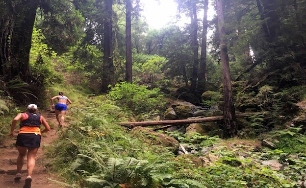
Matt Davis- Steep Ravine-Dipsea Linkup
Stinson Beach, California
This famed Marin County linkup in Tamalpais State Park is about as classic as it gets. In just over seven miles you’ll take on a hard climb, cool off in shaded forests, marvel at towering redwoods and traverse grasslands with stunning views of the Pacific Ocean and San Francisco. Start at the end of Belvedere Avenue and climb up the Matt Davis Trail for 1,500 feet. Make a right to descend Steep Ravine, and another right to finish down Dipsea, venue for the world’s oldest trail race and one of the most famous trails in the Bay Area. If you want to add more difficulty and distance to your run, head up Dipsea, and test your mettle with a grueling climb that includes 688 steps. Regardless, when you are at the car looking back up toward Mount Tam, you’ll be rubbing your eyes thinking it was all a dream.
Distance to nearest town: Stinson Beach, 23 miles from San Francisco, California
Mileage: seven miles
Elevation gain: 1,500 feet