Published April 26, 2017 10:36AM
Pregnant Pause
Seeking new horizons on the diverse trails of the Santa Monica Mountains
Sage. Nicholas. Willow. My mind sorts through names as I blaze past Leo Carrillo State Beach’s Nicholas Flats trail …
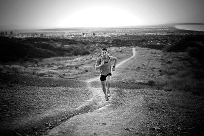
Photo by Joshua Huber
Sage. Nicholas. Willow. My mind sorts through names as I blaze past Leo Carrillo State Beach’s Nicholas Flats trail and wind instead up Willow Creek, toward the backside of the mirador. The name sifting began four months ago, shortly after my husband, Johnny, and I found out that we are expecting our first baby.
ADVERTISEMENT
Although I have only lived at the base of Southern California’s Santa Monica Mountains for seven months, I am compelled to honor these mountains — to mark this baby with a piece of their story. I am so engrossed in names that I almost miss the Red-Tailed Hawk lazily surfing wind thermals overhead. My breath comes out in shallow jabs, signaling that I am no longer myself, but myself and my child.
When I had asked the doctor about running during pregnancy, she said, “It’s fine for you to run as long as you take it easy.”
Take it easy? I had to ask her what that meant, exactly. “When you get out of breath, slow down or stop.”
Big Backyard
I sit on a flat rock next to the trail and peel a tangerine. Uplifted by salt-scented currents, the hawk cruises Willow Creek canyon. The creek mouth empties out near Nicholas Beach, where the rainbow bridge touched down, guiding the Chumash Indians to the mainland from Limuw, or Santa Cruz Island.
ADVERTISEMENT
I continue my out-the-front-door run by walking the rest of the way to the lookout. I imagine pregnant Chumash women standing on this knoll, their eyes scanning the water for paddled tomols returning from the islands. I touch the woody branches of a Toyon Bush aflame with red berries (qwe to the Chumash), suddenly craving a recipe for qwe jam.
For me, the trails at Leo Carrillo are a dream; I lace up on the patio and, without driving anywhere, top out at the ridgeline behind my house in under an hour. The downside is having to endure the earnest excitement of our yellow lab, Ruby, as she watches me slide into running clothes, followed by her heartbroken sighs as I leave her behind (she isn’t allowed on State Park backcountry trails).
Within the Santa Monica Mountains is a 70,000-acre protected recreation area patched together by federal, state, county and city agencies. Spurred by guilt, I discover an alternative to running at Leo: Charmlee Wilderness Park, a dogs-allowed maze of singletrack owned by the city of Malibu.
ADVERTISEMENT
Ruby and I load up and wind our way through Encinal Canyon; it takes 10 breezy minutes to reach the 530-acre park. Leashed together, we meander along the nine miles of trails, taking in shimmering views of Zuma Beach and the azure sea below. Enjoying a drive-by salad bar, Ruby grazes on tufts of tender grass shoots poking through last summer’s dead stalks. She sniffs for squirrels and rattlers as we run through chaparral and coastal sage scrub, along wide-open grassy meadows and coolly shaded oak woodlands. Our backs to the ocean, we face Boney Mountain Ridge and Sandstone Peak, which at 3111 feet is the highest point in the Santa Monica Mountains. Even though Charmlee is only a half-hour’s drive from Los Angeles, it’s completely deserted.
Blowin’ in the Wind
The next day, again, I can’t bear to disappoint Ruby, who’s panting happily, silhouetted by the lavender stirrings of dawn. I’d heard of another spot, Circle X Ranch, which encompasses the highest points in the range and is run by the National Park Service. A photographer friend Rebecca Garrett joins us, and we drive up the Pacific Coast Highway to the legendary Neptune’s Net at County Line and turn up Yerba Buena in pursuit of dog-friendly trails.
We settle onto a fragment of the Backbone Trail that leads to the top of Sandstone Peak. Totaling 65 miles, the Backbone Trail links Point Mugu (the northernmost tip of the Santa Monica Mountains) to Will Rodgers State Historic Park on the south end. Runners typically take three days to complete the entire ridgeline traverse.
ADVERTISEMENT
Gusting Santa Ana winds have succeeded in blowing dust and smog particles out to sea, and I glimpse crystalline views of the San Fernando Valley and verdant Oxnard Plain.
“I hate the Santa Anas,” I say, my mouth parched. Really, what’s loveable about a hot wind that stirs up negative ions, sparks huge hell fires and sucks moisture out of any living thing in its path?
Rebecca looks at me, astonished. “Really? I love them!” I notice her skipping a little.
“Why?”
Rebecca spins around, arms outstretched, “They make me feel free! They’re a gust of lust, making my fingers and toes tingle.”
I stare at her. This is the most emotion I’ve seen from the British-born, Sigourney Weaver lookalike. I almost reconsider.
ADVERTISEMENT
When we reach the top of Sandstone, I am winded, starving and completely hormonal. I collapse onto the volcanic slab and devour two pb&js plus a granola bar, bag of banana chips and an apple. Rebecca has the good sense to get the hell away from me, wandering to the other side of the peak. Ruby sits quietly at my feet, taking in the wrap-around views. From here, we can see the entire Channel Island chain — San Miguel (where I first met Johnny while doing a story for this magazine) to Catalina; all eight islands glisten like a stretched-out necklace.
“What’s down there?” Rebecca points to the valley below.
“That’s where my Uncle Bob’s ashes are.” The last time I’d been up Sycamore Canyon to the small valley that was my uncle’s favorite, I saw two deer grazing where our family held the ceremony to release him.
“And the next valley?” She continues north with her eyes.
“La Jolla. There’s a trail that links from there to Sycamore.”
We swap knowing smiles, realizing of course, that we’re going there.
Miller Time
Photo by Joshua Huber
“If you can only run two trails in Southern California, one should be the Ray Miller Trail, and one should be the Ray Miller Trail in the opposite direction,” claims Santa Monica Mountains trail-running forefather, Stan Swartz, in his book 50 Trail Runs in Southern California. It’s true: The endless cruiser has Mediterranean-like ocean vistas and a gentle incline.
ADVERTISEMENT
“I hardly feel like I’m climbing at all,” says my long-time running buddy, Audrey Newman, who has joined Rebecca and me for a sunset session.
Once we hit the top of the bluff, we have the option to stay with the Ray Miller and make the entire 10.7-mile loop back to the La Jolla canyon mouth, or link up with a fire road to the south and drop into Sycamore Canyon, an ancient Chumash trading route linking the interior valley with the coast.
Both trails are popular running spots; a local trail-running group started by Swartz 20 years ago makes the area a regular destination.
“What about Ray? Or Miller?” Audrey tosses out names as we crest the first lookout. The winter sun slinks down into deep indigo waters just south of the nestled-together Anacapa and Santa Cruz.
ADVERTISEMENT
I stop to breathe in this moment of perfect balance: earth, water, fire and air join together equally, gently shushing the day to sleep. If only there was a name for this feeling of elemental harmony — that would be the perfect name for a child of these mountains.
Bridget Crocker’s adventure narratives have appeared in many outdoor travel magazines (www.bridgetcrocker.com), and she has worked as a professional guide on rivers, oceans and trails for most of her life. She lives near Malibu, California, where the Santa Monica Mountains and the Pacific Ocean collide.
Trailhead: Santa Monica Mountains, California
Getting There. Take the Pacific Coast Highway (linking the just-north city of Ventura with Los Angeles to the south) to hook up with a multitude of trails from the range’s many canyon offshoots. From the interior valley on the eastern slope, several great runs are accessible just off the 101 Freeway.
Seasons. Year-round, although July and August midday temperatures can be sweltering. Check in with the Santa Monica Mountains Trail Runners Club for the inside scoop on the best trails for each season — they meet rain or shine every Sunday morning in Pacific Palisades (go to www.trailrunnersclub.com for details).
Accommodations. Contact Reserve America (800-444-7275; www.reserveamerica.com) for campground reservations in the State Parks at Leo Carrillo, Sycamore and La Jolla Valley/Thornhill Broome. In Malibu, stay at the reasonable, ocean-view Malibu Country Inn (310-457-9622; www.malibucountryinn.com). The Homewood Suites by Hilton (818-865-1000; www.hwsagourahills.com) in Agoura Hills is a comfortable choice for east-side trail access.
Guidebooks. Pick up 50 Trail Runs in Southern California, by Stan Swartz, for spot-on trail descriptions and maps; Guide to the Backbone Trail, by Milt McAuley, is filled with trail profiles, history and tips.
Recommended trails. The Ray Miller Trail is a must-do; off the PCH, take the trail directly south from the La Jolla Canyon parking lot. Climb 2.7 miles for unbeatable Pacific Ocean views and head back around through La Jolla Canyon to finish the 10-plus-mile loop. At the top of Yerba Buena Road, you’ll find the starting point for the Circle X Ranch to Sycamore Canyon run. Linking the highest point in the range, Sandstone Peak, with the beach at Sycamore Cove off the PCH, the 12-mile point-to-point trail offers panoramic views with 1200 feet of elevation gain. Run the trail in the opposite direction and complete the Sand to Sandstone challenge.
At the top of Encinal Canyon off the PCH, the dog-loving Charmlee Wilderness Park has nine miles of wide-open singletrack that can be looped for unlimited mileage and views. Tap the Tapia Park to Century Reservoir run by using Las Virgenes Road south off the 101 Freeway, or Malibu Canyon Road from the PCH. The six-mile, out-and-back run meanders along Malibu Creek and through shaded oak groves, an ideal choice when temperatures soar.
ADVERTISEMENT
Etc. World-renown surfing, diving and snorkeling opportunities abound for rest-day activities. Check with Surfclass.com (805-648-2662; www.surfclass.com) for surfing lessons; Island Packers (805-642-1393; www.islandpackers.com) ferries you to the Channel Islands and offers whale-watching excursions.
Races. The annual XTERRA Trail Run Series (www.trailrace.com) and other races in the Santa Monica Mountains (like the annual Turkey Trot) are organized throughout the year by well-known locals Brennan and Michelle Lindner at Generic Events (310-821-7898; www.genericevents.com).