Published April 26, 2017 10:34AM
Trail Huntin'
Searching for singletrack and finding connection in Baja Sur
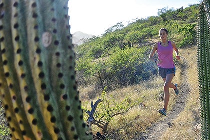
Christina Volken pushing it on the trails of Cabo Pulmo. Photo by Matt Hage.
This article originally appeared in our December 2014 issue. Want more? Subscribe to Trail Runner.
Monday, December 16, 2013, 8:22 a.m.
San José del Cabo
Seven trail runners. Camping gear. Heaps of shoes.
A photographer’s gear bags. A beer cooler so big a family of gnomes could dwell in it. Seven pounds of fresh fish for tonight’s dinner. More corn tortilla chips than I thought existed in Mexico. Personalities and lifestyles all over the proverbial map. Literal maps. Here we all are, on a quiet side street in San José del Cabo, Baja Sur, stuffing all this into two economy-size rental cars so that our week-long adventure can begin.
ADVERTISEMENT
We will sweat through our linen shirts and bikini tops, pushing and prodding gear and bodies around until we all fit, and then we’ll repeat this process almost every day. We will ride low out of town, bursting at the cars’ seams and safe load limits, jostling over potholed pavement and wash-boarded dirt roads. We will grow bold, and drive one of the cars out onto some black rocks the size of tennis balls smoothed by ages of Sea of Cortez waves … until it gets stuck.
We’ll roll through a beer drive-through (a beer drive-through!) in the ’burbs of La Paz. We’ll proudly park in front of the most low-brow lodging in Todos Santos. We’ll drive right up to the edge of the sand (but no farther because of that earlier-learned lesson) just in time to watch the sun fall out of the sky and into the Pacific Ocean. We’ll fight. We’ll laugh. We’ll find trails—loads of them—except for that one time we don’t.
We’re here on assignment to report on trail running in Baja Sur, the Mexican province perhaps better known for surfing, ex-pat life and, let’s be honest, spring-break boozing. While trail running is booming worldwide, before we went south, we found little information about where to do it in Baja Sur. Based upon a few Internet blog posts and info from random sources, we convinced Trail Runner’s editors that there would be a story here. While we indeed discovered plenty of places to trail run, what we found was more than a story about running. We found connection.
Alie Fohner is dwarfed by a cardón cactus. Photo by Matt Hage.
ADVERTISEMENT
Tuesday, December 17, 6:36 a.m.
Cabo Pulmo
Zero-dark thirty and we’re a line of headlamps rolling up the buttery singletrack above Cabo Pulmo on Baja Sur’s eastern cape. There’s just a hint of light in the eastern sky, over the Sea of Cortez, a tease to the luminous miracle that will occur over the next 90 minutes. We ran eight or so miles of these trails yesterday afternoon and decided that we needed to see sunrise from them this morning.
Photographer Matt Hage leads the charge, heaving a 20-pound pack full of camera gear. The only telltale sign of his effort is the sweat pouring from his temples, which reflects in others’ headlamps when we stop for a break. He’s got sexy sunrise photos on the brain so his pace doesn’t lag. Vince Heyd, on the other hand, is terrified of snakes—I’ve seen him launch high-jump-style over garter snakes back in the United States—so he makes everyone else run in front of him, the rest of us his sacrificial lambs.
ADVERTISEMENT
In the middle of these two men is a gaggle of gals: Ashley Gateless, Christina Volken, Alie Fohner, Agnes Hage and me. We couldn’t be more different from one another in personality and physical characteristics, though we do share one commonality: we are strong and passionate trail runners with the calf muscles to prove it.
The singletrack here—a couple of dozen miles of it—is good, super good. Its design and flow remind me of the trail systems of Vail, Colorado, or Park City, Utah, places where millions of bucks are spent to craft them. But Cabo Pulmo’s singletrack has been hand carved, picked, raked and swept by the local expat mountain-biking community over the last decade or so. There are only a couple of hundred people living in Cabo Pulmo full or part time, so we’re talking about a few people’s hobby here.
Everyone in Cabo Pulmo knows about and uses the trails, but there’s almost no record of them beyond local word of mouth. We came here because I heard rumors about the trail system from friends who had previously vacationed here. We asked Getse, a young, unassuming woman with huge, round eyes working at the Cabo Pulmo Beach Resort, about the rumored trails upon our arrival. With a knowing smile, she furnished our group with a Xerox copy of the trail map, hand drawn and cartoonish.
ADVERTISEMENT
Now here we are, our second day of running on this mysterious trail system, watching the sun climb above the sea and through a layer cake of clouds that fire off every color of the rainbow while a just-past-full moon sets over the mountains inland of us. As the morning brightens, Baja Sur’s stark landscape, a mixture of stumpy greenery, cactuses and brown grass that has long gone to seed—becomes bathed in pumpkin-colored light.
Matt takes photos as we run over hill and dale, the light and our muscle-y legs his muses. Alie and I talk to the heavens, asking if coffee could be dropped onto the hilltop for us.
“Could you drop a latte approximately 2.5 miles up the I-don’t-know-what-the-fu#k-this-trail’s-name-is trail?” I ask, with my hands cupped over my mouth to mimic a coffee drive-through.
Alie answers, “Sure, sure, coming right up. Or, ’er, down.”
Christina and Ashley are a bit quieter, introspective, taking in the scene with bright, glittery eyes. Agnes shoots video with her iPhone that she’ll later edit into a hilarious montage. And Vince, well, Vince mentions the lack of snakes every five minutes.
“You guys, you guys,” he says with a smile, “I’m not actually afraid of snakes. Well, just a little.”
ADVERTISEMENT
We laugh; we watch the sun quietly; we run; we just stop and stare. We bond by today’s fiery start.
Christina Volken and Vince Heyd on the 11.5-mile, 6,000-foot climb to El Picacho (7,090 feet), Sierra de Laguna. Photo by Matt Hage.
Wednesday, December 18, 12:30 a.m.
Cabo Pulmo
The roosters begin crowing just past midnight. The moon is bright, just beginning to wane. Maybe the chickens think it’s almost dawn? One’s crow triggers the rest, and it’s soon a cacophony. The village dogs can’t leave well enough alone, and their howls follow. This fray waxes and wanes symphonically until today’s real dawn.
A couple of us had the bright idea of sleeping on the elevated, outdoor porch of our rental house. At one point in the night, when it is clear that we are all awake, Vince quips, “Chicken for breakfast?” We laugh and I roll over, stuffing my head deeper into my sleeping bag.
Thursday, December 19, 3:00 p.m.
Beyond La Paz
“We won’t be able to tell anyone about this, will we?” asks Ashley.
“Are we on assignment for Off Trail Runner magazine?” says Vince, a
half answer to Ashley’s mostly
rhetorical question.
Our afternoon has not gone according to plan. Unlike the trail bonanza we found at Cabo Pulmo, the rumors we chased to La Presa de la Buena Mujer trailhead outside of La Paz—via an almost 20-year-old guidebook and a couple notes we found online about mountain-bike races sometimes happening here—have led us astray.
ADVERTISEMENT
The three of us stand atop a rocky outcrop 1,200 vertical feet above and a couple of miles away from where we started. One direction is a reservoir, its midnight-blue water filled with squawking pelicans on an inland adventure; another direction is the Sea of Cortez, which glows a glorious milky turquoise; and in another direction is the massive sprawl of La Paz, looking as disorganized and chaotic as the city felt when we were there earlier today. Cotton-ball clouds partially block the sun, adding a real-life Instagram filter.
This route, however, described in that old guidebook, has fallen into disrepair, as the trail is tough to follow and some scrambling is required to reach our high point. Perhaps more importantly, a giant but already-ancient-looking “No Trespassing” sign marked the first part of the route, at the dam.
Later, when we’re back on the legal side of the dam and closer to the trailhead, we find some snaking singletrack and doubletrack still marked with yellow ribbons—perhaps from the last bike race here—but run out of daylight after just a couple of miles.
ADVERTISEMENT
We head back to town center, deflated that we’ve been unable to confirm much about the trails at La Presa de la Buena Mujer. We ruminate on the other half of our contingent, which stayed in downtown La Paz to run the city’s famous Malecón, a sidewalk running next to the Sea of Cortez for several miles.
Our mood changes instantly, though, when we spot a Tecate drive-through. It takes a block or two for the concept to register, but then we quickly backtrack. And the attendant, bemused by us three tourists in a dusty rental car, hands us our requested six pack of bottled Tecate.
Back at our hotel a few minutes later, we reunite with the rest of our team, cheers-ing beer and recounting our misadventures. Alie’s answer to our today? “Who cares about the lack of trails? You found a beer drive-through!”
Ashley Gateless (left) and Volken enjoy the long view. Photo by Matt Hage.
Friday, December 20, 4:00 p.m.
Todos Santos
Punta Lobos: at first glance, it seems dark and dearthy here. Gray, frothy clouds loom low over an equally upset Pacific Ocean. The headland, a couple of miles away from downtown Todos Santos and jutting into the ocean, comes to a steep point and is void of vegetation save for small, spindly plants. Dotting the trail up this point are feathers and bird skeletons, literally dozens of them. A foreboding feeling envelops the landscape, and our moods.
Perhaps there is an overswell from the somewhat stressful couple of hours we spent in Todos Santos earlier today, trying to find a place to stay—first, an in-town campground that seemed as dirty and unappealing as Peanuts character Pig-Pen’s playground, then a camping area south of town that didn’t pan out and hotels priced too high for our budget. Finally, in desperation, Matt and Agnes wandered into a cheap hotel and booked us rooms. It’s the kind of place where you sleep on—not in—the bed.
ADVERTISEMENT
Now that our lodging is sorted and we’re out trail running, there’s nothing to be presently bothered about. The sky and the ocean just look much angrier than they apparently are. Our spirits are being re-inflated by Punta Lobos.
“Here! Here! We have to take photos here.” Matt must see the dichotomy we all feel, the contrast of our moods earlier and now, the play of our colorful clothing and shoes against the grayscale landscape, the angry-looking weather and our now-rollicking attitudes. We take photos until the sun sets behind a gray curtain, and then run a couple of miles of singletrack and doubletrack back to the trailhead through a light spray of rain.
Back at the hotel, we all clean up for dinner. Sitting out front of the dirtbag joint, waiting for the rest of the team, a man with wild hair and a necklace laced with giant, multicolor beads wanders up and asks, “Did you see Jesus at Punta Lobos today?”
Playing along with his awkwardness, I say, “I saw a little squall out there. Was that Jesus?”
ADVERTISEMENT
The man doesn’t actually acknowledge my response. His question is more an exclamation than anything, and he continues, “He struck me with a bolt of lightning. Jesus lives!” The man wanders back into the night, and I am left giggling as I wait for my friends.
Because of Jesus Man, an off-kilter day ends even a little more odd. It somehow makes me love Punta Lobos even more.
Volken and Heyd seaside on Punta Lobos. Photo by Matt Hage.
Saturday, December 21, 3:12 p.m.
Todos Santos
“From what distance can a rattlesnake strike?”
The walkie talkie in the front pocket of my hydration pack delivers this message, then lapses into a yelp of radio squelch. It catches us—the gals minus Agnes—off guard.
I press the talk button and reply, “Can you repeat?”
“From what distance can a rattlesnake strike?”
It’s Matt’s voice in an insistent tone, but it still makes us laugh hard. He’s always messing around, in command of the après, and we suspect a practical joke.
ADVERTISEMENT
We’re all on another well-developed trail system just outside of Todos Santos. These trails are the brainchild of Tres Santos, a developer who is putting all kinds of infrastructure into the town. The more than 20 miles of singletrack already in place are, according to Tres Santos, a precursor to many more miles of trails. Some in our group wanted to run longer, and others of us shorter, before meeting on a ridgeline above town for sunset. We carry a pair of walkie talkies to coordinate our rendezvous.
We soon realize that Matt, Agnes and Vince, are, indeed, sharing the trail with a rattlesnake. We learn later, by looking at Matt’s photo, that it was a fat, long snake stretching wide across the trail. The trio saw it before coming within striking distance, though.
A few miles later, our group reunites. Like a child presenting his straight-A report card, Vince announces, “I didn’t run away! I didn’t run away!”
The Baja crew sampled culture along with the scenery. Photo by Matt Hage.
Sunday, December 22, 4:15 a.m.
Sierra de la Laguna
The alarm rings. Ouch, that hurts, are my first thoughts of the day. My body has put in close to 30 hours of running already this week, and I feel it as I rise. Today is our last day of trail hunting in Baja Sur, and it’s going to be our biggest, and perhaps most exciting. My mind finds clarity quickly: we’re going to run up and down El Picacho, a prominent peak at the northern end of the Sierra de la Laguna, a massive mountain range east of Todos Santos. Our out-and-back route will be 21 miles long, with around 6,000 feet of elevation gain.
Of all the places we’ve run in Baja Sur, El Picacho is the route for which we have the most information. In fact, American ultrarunner Nick Triolo, who has been visiting the Todos Santos area for years and who has become a regional environmental activist, has even blogged about hiking and running the route we will take. After a week of literally chasing trails, we’re elated that navigation is likely to be simple. Even so, the outdoor gurus at the Tres Santos Hub—the de-facto outdoor-info source in Todos Santos—have set us up with a guide to the trailhead, which is 12 miles out of town, up an unmarked, sandy dirt road.
ADVERTISEMENT
Our guide, Fernando Arteche, fills us in on Sierra de la Laguna on the 45-or-so-minute ride into the foothills. He talks firm and fast, an explosion of information I’m desperate to remember. He says his great-grandfather bought some 13,000 hectares of high-country land in, he believes, 1893. The land was then passed down through his family, and 6,000 of those hectares were donated back to the Mexican government for incorporation into the 112,000-hectare Sierra La Laguna UNESCO Biosphere Reserve. The reserve was declared in 1994 to recognize and protect the diverse habitat and animals living there. Today, Fernando operates Sierra de la Laguna EcoExpeditions, a backcountry-tourism operation based out of his land.
Fernando says that the northern Sierra de la Laguna is being threatened by an international corporation planning to mine gold, via a giant open pit. He says that Baja Sur’s government has not yet approved the mines, thanks in part to an uproar of protest in La Paz and Todos Santos. All over Todos Santos are bumper stickers, signs and painted murals protesting the proposed mine.
I tell Fernando that I have heard of all this back in the United States, via Nick Triolo, who organized an ultra-distance run transecting Baja Sur from the Sea of Cortez to the Pacific Ocean and through the Biosphere Reserve to bring forth the issue to a wider, perhaps international audience. “Yes, I know Nick, too,” says Fernando. “He sees the tenuousness of our Sierra.”
ADVERTISEMENT
When we arrive to the trailhead, Fernando gives the seven of us an incredible handshake—like a bear hug transmitted through one hand—before the red taillights of his pickup disappear into the still-dark morning. We stand here in moon dust, stirred up by our feet and the truck and illuminated by our headlamps. Thanks to Fernando, we already feel connected to a mountain range we’ve yet to climb into.
The ascent is nothing but a long, grinding way. Some of it is runnable, and other pitches force us to hike. A couple of thousand feet up, desert scrub yields to monkey flowers and penstemon, the more delicate greenery of the wetter, cooler high country. All day we see hikers and backpackers, maybe 15 total.
The final pitches to 7,090-foot El Picacho are a fun scramble, and Christina, who comes from a family of mountaineers, is the first atop the lofty point. It’s just the seven of us on the summit today. We whoop, holler, have lunch and take photos of us full mooning the world.
ADVERTISEMENT
We’ve still got to descend a long, long way back to sea level. And we’ve got one last evening in Todos Santos to soak in the sea breezes, fish tacos and the bonds some of us have created. In the morning, a couple of us will get out on one last Todos Santos trail run before we beeline for the airport. Despite all this, our long lounge on El Picacho feels appropriately final, the crescendo to our journey.
We came here to hunt trails and you bet we found them—good ones that’ll keep you occupied for days of running. And we certainly found the promise of more that remain undiscovered to us. As we stand on El Picacho, I realize that we also found a connectedness that extends to the land, culture and each other.
TRAILHEAD: Baja Sur, Mexico
Getting There. Either drive to Baja Sur or fly into the Cabo San Lucas International Airport. It’s dirt cheap to fly and takes just a couple hours from most places in the United States. I nabbed my ticket out of Denver for under $300.
Getting Around. Cruising on public transport, a curious array of buses of various levels of economy or luxury, is possible between the bigger cities and to the towns on the tarmac connecting them. But to really see Baja Sur, you need wheels. Rental cars are cheap and a no-brainer process here. You can go most places with a sedan, including the dirt roads. Sand is the biggest obstacle encountered off the pavement; don’t drive in deep sand (or on black rocks as we learned)!
Money. The Mexican Peso and U.S. Dollar are widely accepted in most towns. For stopping at roadside fruit stands and such, you’ll need pesos. Aside from the nice to moderate lodgings and larger chain stores in Cabo San Lucas or La Paz, Baja Sur remains a cash-based culture.
Safety. Much is said in guidebooks and travel forums about safety from petty theft and similar on the Baja Peninsula, but we felt 100-percent safe. In fact, we found locals kind and welcoming everywhere.
Culture. Spanish! Bring your language skills or your desire to learn. Locals will politely wait as you stumble through your words with nary a laugh. In typical Mexican fashion, stores and restaurants are open in the mornings and evening, with a multi-hour afternoon closure for siesta.
Environmental Politics. To understand the shaky environmental politics surrounding gold mining in the Sierra de la Laguna of Baja Sur, watch Montana ultrarunner Nick Triolo’s recently released documentary, The Crossing, which highlights the issues at hand, the local organizations working against mining efforts and Nick’s personal protest.
Running.On our Baja Sur trip, we visited just a few of the many, many places to trail run. Should you decide to follow our footsteps, you’ll find great running. And, if you decide to adventure farther afoot, we’re certain you’ll find even more stellar goods along with a couple of dead ends. It will always be an adventure!
Cabo Pulmo. A tiny village located on the potholed and dusty Camino Cabo Este, which stretches up and down the southeastern edge of Baja Sur, Cabo Pulmo is known for its diving, snorkeling and fishing—not its singletrack. When you arrive, ask for the hand-drawn trail map from the Cabo Pulmo Beach Resort office (no joke!). The trails start at the back of the housing community across the Camino Cabo Este.
La Paz. As the capital of Baja Sur, La Paz is a 215,000-person city with big sprawl. It is a 45-ish-minute drive from city center to the closest trails. Perhaps it’s better to embrace where the locals run in La Paz, on the Malecón, an approximately five-kilometer-long paved pathway directly next to the Sea of Cortez. Morning is the most popular time to run, though you’ll see locals running anytime except evening. In the evening, the Malecón turns into the locals’ social center and a place for tourists to take in a Baja Sur city not heavily impeded by tourism.
If you want to try La Paz dirt, find your way out of the city proper and onto Highway 286. Just before the kilometer 13 marker, you’ll see a sign for Presa Buena Mujer. Take a left and drive a short distance back to the gate. Park your car, pass through the gate and get exploratory on the singletrack and doubletrack there. If you can get a 10K run out of these trails, you’ve done well.
ADVERTISEMENT
Todos Santos. Tres Santos is a large-scale, supposedly sustainable development coming to Todos Santos that seems to be mostly accepted by the Todos Santos community. The development company behind Tres Santos has put in some great singletrack. Stop into the Tres Santos Hub in downtown Todos Santos to ask for a map and tips. You can get a 20-mile run by leaving straight from town. More singletrack is supposedly coming along with this development in the future, too.
Sierra de la Laguna. This mountain range makes the north-south spine of Baja Sur, and there are surely hundreds of miles of unmapped singletrack and doubletrack snaking through it. We ran to the iconic El Picacho summit. There’s a brand-new bypass of Highway 19 east of Todos Santos, and finding the dirt road that leads you to the El Picacho trailhead is a little tricky because of it, but it’s essentially very close to where the bypass and the old Highway 19 merge south of Todos Santos. Once you’re on that dirt road, it’s 12 miles to the trailhead. There are a couple road branches, but stay on the most major road at each junction. At the gate 12 miles in, park the car and start running up the dirt road until the trail heads up to the left off the dirt road. The out-and-back gate to gate is about 21 miles.
Meghan Hicks is a Trail Runner Contributing Editor, and recently finished Italy’s grueling, 330-kilometer Tor des Géants race.