Published April 26, 2017 10:34AM
Around Patagonia
Running adventures with friends and a record attempt at the Circuito Torres del Paine
Jason Schlarb near Loma del Pliegue Tumbado, above Lago Toree, Glacier National Park. Photo by Joel Wolpert.
This article originally appeared in our October 2014 issue. Want more? Subscribe to Trail Runner.
It is 3:20 a.m. January 21st, 2014. After staying up to watch another stunning sunset after 10 p.m. in Patagonia’s Torres del Paine, not to mention pre-run jitters, I have barely slept. I crawl out of the tent we pitched in the Torres Grand campground. My fingers tremble from the brisk morning cold as I cinch my shoelaces. I take a few deep breaths and meditate on the task at hand: running 76 miles of boney trail and off-camber scree and talus with over 20,000 feet of climbing. I’ve never run longer than 36 miles alone and unsupported. By 4 a.m., I am running.
ADVERTISEMENT
Trotting up Valle Ascencio, I soon encounter several groups of hikers, also fumbling toward Lago Torres. While the hikers hope to catch the sunrise, I’m focused on clearing one of the valley’s two technical climbs and descents early in my day. The last mile and a half to the lake entails a series of switchbacks through white-granite boulderfields. Although steep, the switchbacks are a treat here in Torres del Paine—most of the park’s climbs are viciously direct and void of friendly meanderings. I make the 4.5-mile ascent to Lago Torres in 1:12.
With light snow now falling, I retrace my steps down from the lake to complete one of the two out-and-back climbs of the circuit. On the way down, I encounter Joel Wolpert, our trip photographer, and whoop and holler. Wolpert is not one for involved salutations or cheerleading and just gives me a simple, “Hey,” and fires off some photos as the sun rises, lighting up the spectacular towers jutting above us. I make it back to the junction of this segment in 2:12.
My day’s mission is to set a Fastest Known Time (FKT) on Circuito Torres del Paine, widely regarded as one of best multi-day treks on the planet. The circuit entails combining the national park’s two sections—the “W,” which climbs the challenging Valley Ascencio, the French Valley, the trail connecting them, and the trail up to the massive Glacier Grey, and the “O,” which is the route circumnavigating the park. Trekkers walk the popular “W” route in about five days, and the “O” route in eight or nine days. During the previous week, my cohorts, Jeremy Wolf and Wolpert, and I had scoped out the circuit in a more leisurely style, camping and staying in huts (refugios) along the way. But now, I’m shooting to run the circuit in under 17:38:21, the current FKT, which was set February 27, 2012, by Rodrigo “Canuto” Errazuriz of Santiago, Chile.
ADVERTISEMENT
Entering Torres del Paine National Park. Photo by Joel Wolpert.
Encompassing an area of over 900 square miles, the Torres del Paine National Park was declared a UNESCO Biosphere Reserve in 1978. Massive glaciation has carved magnificent granite towers (torres), dark-topped behemoths that shoot straight up out of dry, windy plains. The word “paine” is likely a misspelling of the Spanish word for comb (peine)—used here to describe the range’s procession of tooth-like peaks and spires. After Antarctica and Greenland, this region holds the world’s third-largest fresh-water reserve. If the Dolomites and the Himalayas were to ever forge offspring, it would be the Torres del Paine.
ADVERTISEMENT
Giant lakes surround the peaks, each featuring a unique milky hue of blue and green. Guanacos, wild relatives of llamas belonging to the camel family, trot through the fields adjacent the road while birds hover in the gusty winds. The lower valley landscape is fairly dry, sprouting with short South American beech trees, thorny brush, bushes and grasses.
Among the mountains, the forest becomes thick with tall beech forests spotted with the famous Calafate bushes and their tart, dark-purple berries. Small springs and snowmelt cascades are everywhere, and park rangers boast that all the water in the park is safe to drink. So abundant is the water that I only carry one 20-ounce handheld bottle on my run.
Rockin’ in Glacier National Park, with Fitz Roy in the distance. Photo by Joel Wolpert.
ADVERTISEMENT
My FKT attempt was born of a collaboration between me and my running buddies Jeremy Wolf (known as “Wolf”), 34, of Missoula, Montana, and Matt Low, also 34, of Arlington, Virginia. For the past 11 years, the three of us have concocted adventures throughout the mountains of North America and beyond. We all met at Montana State University, where we ran track and cross country. After graduation, our friendships have only grown stronger during our wilderness get togethers.
After college, both Matt, a tall guy with bright blue eyes and a Leave-It-to-Beaver friendliness, and I served in the Air Force, after completing ROTC together. Wolf is a level headed guy whose calm demeanor is a good balance to my typically outspoken personality, and works as an engineering consultant. We all three are married now and have kids, but refuse to say good-bye to pushing our limits in the mountains.
Past trips have included Mexico, Europe and Canada. In the Andes of Bolivia and Peru, we have run, backpacked and climbed peaks, including 18,000-foot Ishinca and 20,000-foot Huayna Potosí.
ADVERTISEMENT
In the last three years, we have focused on the simplicity of long-distance trail running, inspired by the potential to explore vast swaths of mountainous terrain on foot. Last June the three of us ran 100 miles over five days in the snowy Italian Dolomites and produced a video called Opening the Route. After that trip, we committed to this expedition in southern Patagonia. Unfortunately, Matt’s job obligations precluded him from joining us.
Wolf and I were focused on an FKT of the O and W circuit of Torres del Paine National Park. Wanting to document our adventure, we recruited Joel Wolpert, 31, of Belington, West Virginia, who had recently filmed and produced In the High Country, a running film with renowned ultrarunner Anton Krupicka. In addition to Joel’s skill with the camera, he is one of the few guys who can keep up on the trails and through the mountains while carrying a camera.
The agenda for our 15-day trip was to spend the first five days running and filming the O and W circuits, staying in refugios along the way. Then we would head five hours north to El Chalten, Argentina, a tiny town at the entrance of Glacier National Park, home of the famous Fitz Roy and Cerro Torre peaks. In El Chalten we would take an easier week of mountain running before attempting the Torres del Paine Circuit FKT.
ADVERTISEMENT
Camping near Torres del Paine National Park. Photo by Joel Wolpert.
Approaching Torres del Paine, we were bursting with excitement. “These mountains are just so amazingly steep,” I kept repeating.
“We have to get out of the car and check them out,” Wolf replied. We ended up doing just that three times in a couple of miles before even entering the park.
ADVERTISEMENT
After paying our fees at the park entrance, we quickly set up camp, suited up and ran up the steep trail to Lago Torres. Perched above steep talus slopes, the lake sits at the base of the impossibly smooth towering peaks. As we quickly cooled off, we opted to continue our adventure off trail and up a side drainage climbing up scree and snow that turned into rock scrambling. With around 19 miles of running and over 6,000 feet in vertical, we had our first fix of Patagonia mountain trail running.
Pre-dawn the next day, the sound of rain and wind whipping our nylon tent flys awakened us. We quickly agreed to sleep in, then, around 9, the rain slackened and we began the task of drying tents and organizing for the next four days of running from hut to hut.
Shouldering our packs, we ran toward the French Valley of the W circuit, buffeted by 50-to-60-mile-per-hour winds. The only “rain” we experienced was from water blown out of the lake and whirl-winded against our bodies. We had never seen lake water transformed into 40-foot cyclones. That evening, after meandering through an eerie burnt forest we arrived at Refugio Paine Grande, situated on the banks of an enormous lake. We relished hot showers, a bottle of wine and comfy beds.
ADVERTISEMENT
The refugios around Torres del Paine are all unique. Inside this one, which would be the trip’s largest, backpackers, predominantly European, enjoyed dinner at tables. Outside, packed like sardines, were nearly a hundred tents full of primarily South Americans, festively singing, eating and drinking.
The next day, our exuberance came to a screeching halt when we encountered several park rangers. “Running is too dangerous and not allowed,” said one. “We don’t want to have to come rescue you.”
“We will slow down and be extra careful. Don’t worry. We won’t get hurt,” was my stuttering, startled response, which seem to appease them. We had seen no signs or warnings against running and thought that perhaps we had just run into some rogue rangers who had simply made up the rule.
Then the next day, we were again stopped by a group of rangers who told us running was not allowed. Again, Wolf and I quickly responded that we would slow down, walk and be very careful.
“I don’t believe you,” said one of the group. “My boss will come by the refugio later and talk to you about not running in the park.”
ADVERTISEMENT
I was frustrated. Wolf appeared concerned, but not as visibly irritated as me, and Wolpert seemed to not be upset at all. After eating a late lunch, anger subsided and we all felt we could resolve the situation when the time came.
Before dinner, we ventured off for some exploring. Near the end of a nearby lake we found a small bay sprinkled with bobbing icebergs. I saw an opportunity—to hopscotch icebergs to the opposite side. Halfway across, I slipped onto my butt and sliced my hand but popped back up, continued on and made it to the other side without swimming. Now I paced on the bank, ready to reverse the task.
“You can just walk around the shoreline, dude!” shouted Wolf, sensibly. But with Wolpert’s camera still rolling, I made the return trip without incident.
No rangers showed up that night or the next morning, and we agreed to walk through camps and near refugios and be on the lookout for rangers. We even concocted a code word—“Blob”—that would indicate one of us had spotted a ranger.
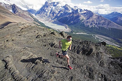
Schlarb negotiating Glacier National Park’s rugged terrain. Photo by Joel Wolpert.
ADVERTISEMENT
On the trail to John Gardner Pass we were half relieved to not encounter the rangers, and half disappointed we couldn’t resolve the issue. Our thoughts were replaced with views of Glacier Grey from the pass and the bliss of running down fun, technical trails on the other side.
Soon, though, a mud bog stopped us in our tracks, literally. At one point, I lost a shoe in the mud, and Wolf and Joel had to fish it from the sludge. The several-mile-long mudfest sapped a lot of energy, some of it laughing at each other flounder.
Refugio Dickson, our home for the night, was a stark contrast to the Paine Grande. There, our room had no real ceiling, just nine-foot walls that ended short of the roof, a skylight the only window. We couldn’t all stand at the same time. My bed was just a few feet under and perpendicular to Wolf and Joel’s. The common areas included a medium-sized room with two tables, a kitchen and some couches. The refugio was manned by college-age South Americans, who were constantly laughing and playing games.
ADVERTISEMENT
That night we played card games, had a few more beers than normal and got to know some of the backpackers. We met a couple who was traveling the entire length of both North and South America, a group of college friends from Buenos Aires and some crazy New Yorkers. In their card game, the objective was to make the most vulgar and politically incorrect statement with a number of short phrases written on pieces of paper you were dealt. The inappropriateness and vulgarity were voted upon at the end of the round to determine the winner.
Along with the levity, Wolf and I set objectives and strategies for our FKT attempt. Running the eastern valley first and continuing in a counterclockwise direction, like Canuto had done, made the most sense. Getting the busiest valley done before 6 a.m. would be a distinct advantage; then we’d cover the seldom-visited eastern and northern sections of the O circuit during the morning, which would leave the busier western and southern sections for the late afternoon and evening when most backpackers were settling into refugios. We would each take one water bottle, fill at the numerous creeks and take 100 to 150 calories of Vitargo per hour. Our goals were: first, have fun and keep the first half comfortable; second, complete the circuit; and, third, set an FKT.
The Americans ran into accomplished Japanese ultrarunner Hiroki Ishikawa, who was running the O and W in three days.
ADVERTISEMENT
After completing our five-day tour around the O and W circuit, we traveled north five hours to El Chalten, where we were once again greeted with a spectacular skyline of glacier- and snow-shrouded peaks. The mountainous skyline of El Chalten is featured as the logo for the outdoor company Patagonia. As a climber, Wolpert was particularly enamored by El Chalten and its rich climbing history.
“When I return to Patagonia, this is where I will go for sure!” he exclaimed. The mountains and well-maintained trails quickly dashed our plans of taking it easy, which would catch up with Wolf. Coming down from our last run there, just a few miles from town, he came to a halt. “My knee is bothering me; I’m going to walk back to camp,” said Wolf. Unfortunately, the injury would end his chance at running 75 miles three days later.
Back on the FKT attempt, at the first junction of the W section, I am running east to the campsite where we slept the night before. Wolf is there, and I sit down at the picnic table to update him. Knowing that he is still stung by having to bow out, I avoid showing too much enthusiasm.
Wolf says, “You look great. How are you feeling?”
ADVERTISEMENT
“I’m great, man, but wish you could be out there with me.”
Wolf is never one to show much emotion, but I can tell by the look in his eye that he wants to be running. He tells me, “Have a great day out there,” as I take off through a sleeping village of tents.
A few miles past camp I fall into a steady rhythm and pace for the longest runnable, 25-plus-mile section, a rolling open valley, part of the O circuit. My heart feels open, and my breathing is easy. I run with the naive confidence of the collegiate track athlete I once was. I pass through Camp Seron in the heart of the farm-like terrain at 19.5 miles, 3:46 into the run, a bit faster than record pace.
ADVERTISEMENT
Soon, I’m cruising through the last part of the wide meandering valley toward Refugio Dickson, where the more steep mountainous terrain begins. Things go well on this section, and I gain a 20-minute lead on Canuto’s split, which I had memorized from his FKT report.
I arrive at Dickson in 5:39 through 31 miles, and stop just long enough to mix some more Vitargo into my bottle. I’m using this concoction supplemented with a few bars as “real food” rewards.
I decide to quit worrying about the FKT and focus my mental energy on smaller goals, like getting to the next camp, over the next climb or through a forest section. As rain begins to pound down, I negotiate the mud-bog section using all sorts of awkward dance and gymnastic moves. Soon, the rain turns to heavy snow and the wind is now ripping, stirring my primal instincts.
ADVERTISEMENT
Approaching treeline and then above, I run faster than I should but I am in the moment. I encounter some hikers and they relay that rangers are on their way up from the other side to close the pass due to the treacherous weather. I know that the rangers are not going to react well to a mud-covered runner in shorts sprinting over the pass in near white-out conditions.
Jeremy Wolf and Schlarb on Loma del Pliegue Tumbado, Glacier National Park. Photo by Joel Wolpert.
I’m not about to just turn around. I decide that, if the pass is closed, I’ll avoid it and scramble over a peak and keep going. Just before the pass, though, the snow stops, and I see no rangers. Relief. I’ve run 41 miles in 8:09.
At the pass you can see the miles-long Glacier Grey, an ice-cream-like formation flooding the valley below. Down the backside, I descend toward Refugio Grey. The trail is so steep and direct that there is a metal railing on the steepest section for hikers to cling to. In a matter of 45 minutes I go from a blizzard to sunny T-shirt weather.
At the mouth of the out-and-back French Valley, just 13 miles from my finish, I hit the route’s last big climb, but am reduced to an exhausted power hike. At one point, a long glacier snakes down the valley with a several-thousand-foot-long hanging glacier intersecting from above. The hanging glacier drops bus-sized chunks of ice to the valley floor below creating an enormous thunder.
ADVERTISEMENT
Struggling now, I make the end of the valley in 13:16 with 62 miles covered, but shamefully walk some of the ensuing technical descent. The next mile-long section doubles as a creek, and the cold water revives me.
Running along the base of the mountains and around the huge lakes, I succumb to continually checking my watch. The only things keeping me going now are comforting images of my wife, Maggie, and our 3-year-old son, Felix.
Then with my brain screaming at me to stop, I hit the final mile to the finish. I see Wolpert in a bright yellow T-shirt at the bridge marking the end and pour out a final push, then glance at my watch—75.6 miles with 20,100 feet of climbing in 16 hours 20 minutes, an FKT by over an hour for the O and W Circuito Torres del Paine.
Alongside the Paine River on the east side of the O and W circuit, Torres del Paine National Park. Photo by Joel Wolpert.
Trailhead
Running Torres del Paine National Park, Chile, and El Chalten area, Argentina
>Getting There
Tickets are relatively expensive to Punta Arenas in southern Patagonia and usually require purchasing a separate ticket from Buenos Aires or Santiago to Punta Arenas on LAN airlines.
Several rental-car companies operate at the Punta Arenas airport. To travel across the border to Argentina, as we did, you will need to arrange a rental that provides special documentation, which costs several hundred dollars more.
>Accommodations
Erratic Rock Hostel (www.erraticrock.com) in Puerto Natales (the last town before heading into Torres del Paine National Park), just a few hours from Punta Arenas, is a fantastic hostel in a fun town. The staff is incredibly helpful, informative and speaks English (the owners are from Oregon).
Visit www.torresdelpaine.com for general information on Torres del Paine National Park, basic maps, information and links to book refugios and camping permits. Our favorite refugios were Dickson, Grey and Cuernos, but all the refugios and hotels are nice.
>Seasons
January and February are the best months to run in Southern Patagonia. Weather in Southern Patagonia is always variable. It can snow at anytime in the mountains, and wind is to be expected.
>Recommended runs
In Torres del Paine, the must-do runs are:
ADVERTISEMENT
1) Lago Torres and the “towers.” Begin from Hotel Las Torres; 14 miles round trip (distances are provided on signs en route).
2) Paso John Gardner and Glacier Grey. This run from the base of Glacier Grey (near Refugio Grey) has amazing views of the glacier and tops out above treeline at John Gardner Pass. You can reach Refugio Grey by catamaran (ferry) or by running 20-plus miles from Hotel Las Torres.
3) The best multi-day run in the park is the “W” circuit, which includes both major valleys and John Gardner Pass. Plan to take three or four days to run the W and stay at some combination of: Hotel Las Torres, Refugio Cuernos, Refugio Italiano, Paine Grande and Refugio Grey. After doing John Gardner Pass, you can either take a combination of catamarans and shuttles back (with advance planning) from Lago Grey or Paine Grande, or run all the way back to Hotel Las Torres. In three to five days you can either circumnavigate the park by running the O circuit, or run both the O and W circuit.
ADVERTISEMENT
At Glacier National Park, near El Chalten, Argentina, the trails are very well maintained and generally more “runnable” than at Torres del Paine. Most of the trails can be done in a day. There are no refugios in the park for multi-day trips. El Chalten conveniently borders the park, with multiple trailheads just a short jog from anywhere in town. Groceries, restaurants, hotels, hostels and campgrounds are all available in the small town of El Chalten.
Jason Schlarb is a professional mountain runner and coach living in Durango, Colorado. You may view the film Around Patagonia about their trip at www.schlarbwolf.com.